Coverdale Abbey & Climbs
Route Information
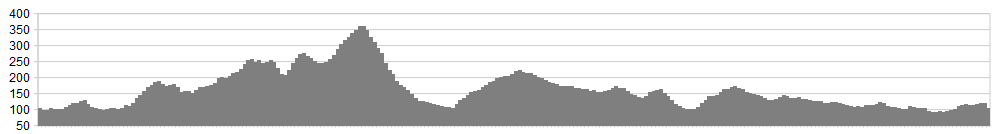
Stats: 34 miles and 2650 feet of ascent
OS Map: ![]()
Refreshments
The tearooms at Jervaulx Abbey are amongst the very best in the Dales – indeed, anywhere. In terms of a stop along the way, we’ve taken this route into Leyburn, where all manner of options await you. When parking at the tearooms, please try to use the far end of the car park whilst you’re away cycling.
Character
This route takes part of the 2014 Tour de France route – in reverse – climbing steadily to the historic Dales village of Middleham, with Richard IIIs castle and gallops. You then enter beautiful Coverdale, climbing along narrow, winding lanes, before descending and crossing the River Cover for the second time. The road then takes a steep ascent to Pen Hill, before a narrow twisting, and somewhat dangerous descent (if not taken carefully) to West Witton and Wensleydale. An easy amble in Leyburn brings on some more quiet lanes to finish this super ride, before more tea and cakes at Jervaulx tearooms.
Route
1. From Jervaulx Abbey, turn left onto the A6108 and ride along the 2014 Tour de France Grand Depart route (in reverse), all the way to Middleham. The road climbs at a steady gradient to East Witton, before bending right, through the village and dropping at speed to Cover Bridge, where it bends left and gradually rises to historic Middleham and the Castle of Richard III.
2. At Middleham, the road dinks right, around the village cross; however, ignore this, instead leaving the A6108 to the junction on the left of the road (in effect straight on), climbing through the village, and exiting towards the famous horse racing gallops that lead into Coverdale. An initial sharp climb soon eases off, as you wind and roll along to Coverham Abbey, where a small chapel now sits. Take the very minor junction to the left, signed ‘West Scrafton’ and ‘Swineside’.
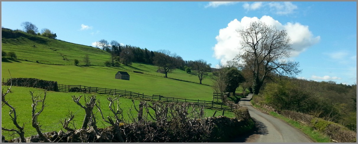
3. This minor lane winds its way down to the River Cover, crossing via a delightful old packhorse bridge, in a glorious setting that hasn’t changed since medieval times. Once over the bridge, follow the road around to the right and climb steadily as the road cuts through Coverdale, with superb views all around.
4. At West Scrafton, the road twists and turns its way through the hamlet, before descending back down to the River Cover. Take care here, as the road may well have been re-surfaced with fresh grit, and the twisting nature may catch you out. If taken with respect, the descent is superb and very enjoyable.
5. Another packhorse bridge takes you back over the River Cover, before the road climbs up to meet the main lane through Coverdale, joining Middleham with Kettlewell. Turn right at this junction and ride into Carlton village. Once through the village, a junction left is signed for ‘Melmerby/ Wensley/ Leyburn’ – take this and begin the climb to Pen Hill. A mile or so up the road, Melmerby is reached, and a junction left is take, signed for ‘West Witton’, continuing the climb.
6. Open moorland guides the way to the summit, as the road then descends, crossing a cattle grid and twisting sharply through severe and steep bends, all the way down to West Witton. Take care on this descent, as it is steep and very twisting and may catch the over-enthusiastic out. Safely negotiated, West Witton is reached, and the junction with the A684 main road through Wensleydale. Turn right and cycle down at speed to Wensley and the bridge that crosses the river Ure, then climbing up to Leyburn and a break.
7. Leave Leyburn on the A6108 signed to Richmond, climbing towards Bellerby. A half mile out of Leyburn, take the minor junction on the right towards Garriston. This level and straight road allows the opportunity for some head down riding, before crossroads are reached and you turn right, descending to the A684 at Stoop House Farm. Cross the A684 with care, then ride under the railway bridge, before continuing the descent, down towards the two rivers of the Ure and the Cover at Ulshaw – but DO NOT cross the rivers…
8. Instead, turn left and take the narrow lane that visits Low Hutton and Thornton Grange, along hedgerows and meadows, to a ‘T-junction’, where you turn right signed ‘ Newton Le Willows’. Stay on this quiet lane, ignoring the Newton Le Willows junction when reached, instead taking the next junction right, opposite Cocked Hat Farm, onto Marriform Lane.
9. At the next crossroads, head straight over, signed ‘Jervaulx’ and stay on this lane until it joins with the A6108 once more. Turn right and cycle back along to the tearooms and a well earnt rest.
click below for gpx file


