Dallow Moor & Brimham Rocks
Route Information
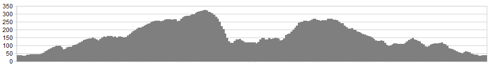
Stats: 29 miles and 2500 feet of ascent
OS Map: ![]()
Refreshments
Pateley Bridge has excellent cafes and is also home to Kendall’s Butchers, home to the best steak pies and pork pies in Yorkshire. Back at Ripon there’s lots to choose from as you plan the next ride from this great cycling venue. Don’t forget to nip into the Moonglu bike shop for any tweaks that need sorting.
Character
This is a hilly route, that whilst not great in length, will definitely test you out. The descent into Pateley Bridge is epic and alpine in nature, and should be treated with caution. Once you’ve climbed out of Pateley Bridge, it’s downhill all the way home.
Route
1. From Ripon, head out of the city on the B6265 towards Pateley Bridge. Passing the garden centre on the edge of the city, turn right towards Galphay at Studley Cricket Club and begin the climbing. The road gently ascends for a few miles, before dropping down steeply, through trees, twisting right and over a bridge, before a steep climb that leads to Galphay village.
2. At the village green, the road bends right towards Kirkby Malzeard – continue along this, with high hedgerows and meadows lining this narrow lane. The lane eventually drops down to a junction. Turn left at the junction, heading towards Grantley. Cross over Gate Bridge and climb gently. A further 1/4 mile ahead, a junction right indicates a narrow lane signed for Pateley Bridge – take this turning. This narrow lane (Missies Lane) twists its way through beautiful countryside, before straightening out and rolling along to Dallow Moor. Drystone walls then guide you over the cattle grid and onto the open moorland.
3. The steady upward gradient continues, with short respites as you head out into Nidderdale proper. A junction left is passed by and ignored, as the road heads towards the twisting descent of Skell Gill Bank, crossing Skell Gill Bridge before climbing steeply.
4. Keep concentrating though, as we need to turn right at the top of the bank, heading to Pateley Bridge via Bishops Moor and Old Church Lane. This lane continues to climb steadily, crossing a cattle grid, before the KOM is finally achieved and large boulders either side of the road, seem to mark the point where brakes should be checked and the real descending begins.
5. Old Church Hill is an awesome, alpine style hill, so treat it with the utmost of respect, and descend carefully. It narrows significantly, with high drystone walls, and sharp bends that come up unexpectedly. Don’t worry about your Strava placement, worry about your bike handling!
6. Once safely down, unclip and head for a café, or for my personal choice: Kendall’s Butchers, for a great steak Pie (top of the High Street!) – snacks or lunch taken, time to move on.
7. Ride over the bridge at the bottom of the High Street and turn left after the Cattle Market, through Bewerley and on to Glass houses.
8. At Glasshouses take the short but steep climb that leads to the B6265 road between Pateley Bridge and Harrogate. Turn right in the direction of Harrogate. Half a mile along this busy road, ignore the junction and the steep climb of ‘The Raikes’ on the left, but do take the very next left after this, heading up the climbing lane to Smelthouses and Brimham Rocks. This narrow lane climbs endlessly for 1.7 miles, to a crossroads near the Brimham Rocks car park.
9. Turn left, cycling past Brimham Rocks, staying on this winding lane for 1.7 miles, until a junction right is signed for ‘Warsill’ and ‘Bishop Thornton’ – take this.
10. This lane continues downhill at a steady gradient for just under 3 miles, all the way to the junction with the Fountains Abbey Road. At the junction, turn right, cycling along and up for 1/2 mile until a junction left should be taken (Watergate Lane) passing the hamlet of Haddockstones, How Hill, before dropping down to the rear entrance for Fountains Abbey, where the road turns sharply left and climbs steeply.
11. The climb is short lived, and once at the top, turn right onto the Fountains Abbey visitor centre road, continuing past the visitor centre roundabout, along the road, to the gate on the right which leads into Studley Royal Deer Park.
Now descend at speed all the way through this sculptured landscape, to Studley village and back to Ripon.
click below for gpx file


