Grasmere and Loughrigg
Route Information
This route is a great introduction to Lakes mountain biking. We put it together after the flooding in December 2015, to show what a great place for riding Grasmere and the surrounding fells area.
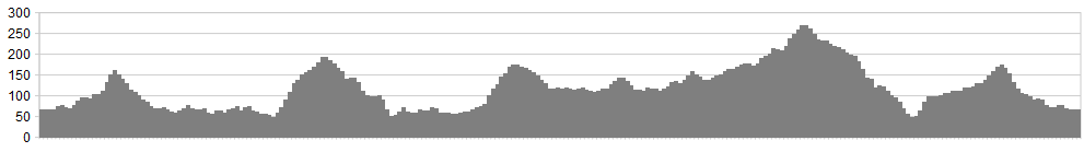
Stats: 20 miles with 3150 feet of ascent
OS Map: ![]()
Refreshments
There are ample little cafes, restaurants and pubs to choose from in Grasmere, along with great places to stay over, including a Youth Hostel. If you do extend the route, then Hawkshead provides a welcome break along the way.
Character
This route rolls and climbs around the fells close to Grasmere and Ambleside, using the lanes to weave together a great route. There’s nothing too testing about the route in terms of technicality, which can easily be extended to Knipe Fold and Hawkshead, to take in the Hawkshead Hilltops route or a trip into Grizedale.
Route
1. From the far end of Grasmere village climb steeply on Red Bank Lane, turning left at the top onto Loughrigg Terrace. Enjoy a cracking little descent to the Ambleside road.
2. Turn right as the track pops out on the lane (bridge seen to the left) climbing the steep hill over the cattle grid and continuing up until the BW is reached on the right near Brow Head Farm, crossing Loughrigg Fell and descending to the road at Skelwith Bridge.
3. Turn right onto the B5343 and cycle along until a BW is signed in trees, joining the River Brathay track all the way into Elterwater village. Turn left at Elterwater on the lane, passing the hostel before taking the track on the right, just after the Elterwater Inn, leading to Little Langdale.
4. This track climbs initally before dropping to the lane at Little Langdale. At the junction turn right and follow the narrow winding lane, passing Little Langdale Tarn. Cross the cattle grid and turn left signed towards Eskdale, taking this lane for a short distance before a track leads off left and rolls along with easy climbs along the way, eventually joining the A593.
5. Exit onto the A593 and turn right. Continue along until a Byway on the left, on the opposite side of the road to ‘High Oxen Fell’ (signed) is taken, passing holiday cottages (small sign). This track climbs steadily before joining a BW on the left which descends, speeding you back down towards Skelwith Brdige, across the edge of Black Fell (OS Map).
6. At Skelwith Bridge turn left and retake the lane from earlier, climbing steeply before taking the BW around Loughrigg Tarn. This BW eventually rejoins Red Bank, dropping you back in Grasmere.
click below for gpx file


