Hebden Bridge Reservoirs
Route Information
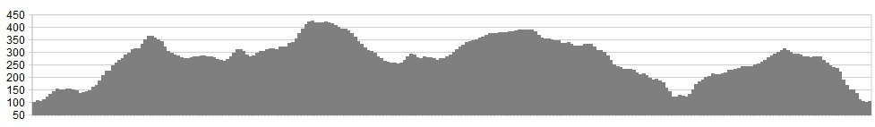
Stats: 25 miles & 3131 ft of ascent
OS Map: ![]() Refreshments
Refreshments
The Lamppost Cafe, just off Bridgegate, is an excellent spot for riders. However, the choice is varied in this great little Pennine town. Car parks and cafes abound, as do great sandwich shops and pie shops – commonly known in the north as your local butcher.
Character
A little bit of everything, terrain wise, from this route starting and finishing in the characterful little market town of Hebden Bridge. Some steady fire-road climbing initially followed by farm roads and rolling tarmac through some beautiful countryside. The route turns more off-road on reaching Widdop Reservoir after which a steep switchback climb will take you to the highest point on the route offering great views. You’ll then be rewarded for your efforts with some fast, rocky descending, nothing too technical, a couple of water crossings and views of the fascinating Limestone Hushings in Sheddon Clough. After gaining more height on the road, some further, entertaining descending on mixed terrain takes you down to the valley bottom after which the Pennine Bridleway below Stoodley Pike will take you back into Hebden Bridge.
Start in Hebden Bridge itself, where there are excellent facilities.
Route
1. From Hebden Bridge take the A6033 Keighley Road. Turn off left along Midgehole Road towards Hardcastle Crags after the bus stop.Pass the first Hardcastle Crags visitor car park and take the next right turn towards pay and display car park. Climb straight ahead for approx 1.5miles.
2. Turn left up steep Calder/Aire Link climb signposted just before derelict farmhouse. Go through the gate and continue along Calder/Aire Link following wall on left, another gate, then descent on the field track to farmstead at Walshaw.
3. Straight ahead through farmstead and follow the farm road which becomes a newly surfaced road. The road ‘S’ bends left then right, over cattle grid and then climbs to a junction. Fork left, then left again and join the Pennine Way, passing trees on the right. A short descent is enjoyed on the road, then turn right to join Ridehaigh Lane.
4. Turn left at Widdop Reservoir car park and cross the cobbled dam wall. Go through the gate and follow the trail which soon becomes a very steep and loose switchback climb.
5. Passing rocks at the summit, follow the track straight ahead, becoming a fast, loose, descent with several jumps for approximately 2 miles. Following this, turn left at a gate and drop down to Hurstwood Reservoir.
6. Passing Hurstwood Reservoir, turn left by the pylon (taking either track) and climb steadily, passing views of The Hushings to your left, then take a short drop down to Cant Clough Reservoir. Go through the gate, along the dam wall and through a further gate.
7. Follow the obvious trail to the walled bridge over Sheddon Clough stream, then ride through the stream itself and over a small bridge (or through stream again). The trail then climbs again, before a fork to the left, later emerging in a carpark.
8. Turn left out of the carpark and follow the road, ‘The Long Causeway’, for approximately 2 miles. Turn right down Mount Ln signposted Shore and then left on bridleway Delf Lane. Follow obvious trail straight ahead for Approx 2 miles.
9. On reaching a road crossing after Brents Wood head straight across and up steep walled climb. Follow for a further half a mile past golf course – please respect the golfists 😉 before emerging in golf course carpark.
10. Head straight through the carpark and turn right at the road. Turn left at the road junction, passing a church, and follow road until Bean Hole Head House. Turn right down bridleway behind. Follow bridleway until in joins farm track Baulk Head Lane and turn right.
11. Turn right into farmyard (please respect the residents) and follow the bridleway between houses, into the left corner of the yard. Descend the zigzags into carpark and picnic area.
12. Turn left along the main road and then right signposted for Youth Hostel. After the bridge turn right and cross another bridge over the canal. Follow the road to the right and begin to climb Shaw Wood Lane. Turn right at switchback junction, again signposted Youth Hostel. Follow straight ahead New Road / Cross Lane / Mankinholes Bank until sign for Pennine Bridleway left.
13. Follow Pennine Bridleway straight ahead, traversing Stoodley Fell, becoming Kilnshaw Lane / Jumps Lane and the cobbled descent Spencer Lane before turning after houses and descending further through woods to the railway bridge. Exit Hebden Bridge railway station onto the A646 left back into Hebden Bridge.
Now take a look at some more images by photographer, Ed Sykes here
click below for gpx file


