Lady Anne and the Wild Boar
Route Information
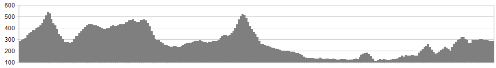
Stats: Be warned, only a few of the 38 miles are easy miles and none of the 5,000 feet of ascent are easy feet. Memory Map has this at over 5,300′
OS Map: ![]()
Refreshment
This is a wild and remote ride with long stretches away from civilisation but there are opportunities to eat and drink at Sedbergh, Dent and Appersett (Moira Metcalfe’s art studio serves hot drinks and scones).
Character
This is a tough but magnificent loop around the North-Western Dales involving five substantial climbs and some wild, remote trails. It takes in the northern shoulder of Wild Boar Fell and the full length of Lady Anne Clifford’s Highway. You could start and finish in Sedbergh, Dent, Hawes or Mallerstang but the route is described starting from Street (near Ravenstonedale) so the biggest climb is with fresh legs.
Route
1. There’s plenty of roadside parking, as long as you aren’t pulling a caravan (council signs line the verge to ward off travellers). Set off up the lane to Stennerskeugh, past the ostentatious gates and the folly, with signs for “Pennine Bridleway” leading to Mallerstang. Fork left at a fallen tree (September 2011) and head upward to the slight dip on the skyline.
2. The descent is likely to be wet so go easy on the brakes. Initially it is well-defined before a sketchy stretch across the most tussocky field in Christendom. A stone-based trail soon resumes and swoops down to the road under a railway bridge. Mallerstang Edge rises in front like something from Trotternish or Conan-Doyle’s Lost World.
3. Turn left and follow the B-road briefly until a sign points back and up to Hell Gill Bridge. This byway is Lady Anne Clifford’s Highway, named after the redoubtable 17th Century noblewoman.
Climb gently but persistently to Mary Bourne’s evocative sculpture “Watercut” and then keep contouring at around 400m, forking left after the impressive gorge of Hell Gill. Ignore bridleways turning right and keep going on the byway to Cotter End. Plummet down this to the road at Appersett. After a mile of tarmac, nourishment may be sought at Moira Metcalfe’s art studio on the left.
4. Leave on the lane marked “unsuitable for wide or heavy vehicles” by Widdale Bridge and join the B-road for a while before turning right at Widdale Foot. Go through coniferous forest until the track turns into a peaty wallow chewed up by irresponsible scramble bikes. When you reach the brow at 526m, however, the descent is a gem, rattling down under Artengill Viaduct, with only the rain gutters to worry about.
5. Spin down Dentdale on tarmac. If feeling energetic, you can go over to Sedbergh by Rawridding but our route hugs the lanes until SD668 896 and the easier track to Millthrop (See picture, below right).
6. From Sedbergh, head out on the A683 to Brough, then fork left at the speed camera sign.(See picture above) Climb gently on tarmac then follow a long, sinuous feast of singletrack along the skirts of the Howgills. After a deep ford, climb to Narthwaite and head right.
7. At a second ford (Wandale Beck) climb out by a limestone ramp then fork left, up through birch and hazel woods. When the wood peters out, the trail is indistinct, but maintain your course, heading for a large barn. After Murthwaite, a good road drops down to the A-road at a small Wesleyan chapel and an even smaller phone booth.
8. Head straight over the road and up the byway through a ford (a useful opportunity to wash off the worst of the muck). At the top, turn left on tarmac and follow this until it re-joins the A-road. Follow this back to the car.
click below for gpx file


