Linnet Clough
Route Information
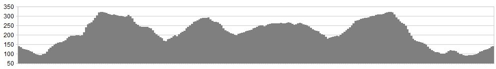
Stats: 12.5 miles and 2050 feet of ascent
OS Map: ![]()
Refreshments
The Little Mill Inn at Rowarth has always looked tempting whenever I’ve been past.
Character
I was introduced to this area by uber-distance-expert Rob Dean when we both worked in Hazel Grove. This was the default after-work excursion, usually fumbling through wintry nights by head torch and bar light. On one very frosty night, Rob managed a particularly graceful ‘off’ by the golf course, continuing to toboggan down the slope for several dozen metres without the aid of a toboggan. It’s a surprisingly varied, scenic, interesting and wild excursion on the fringe of Greater Manchester. Only the short section flanking Lantern Pike is technically in the Peak District National Park, but you won’t let boundary-snobbery get in the way of a good ride, will you?
Start Point: Park considerately in or near Oldknow Road
Route
1. Hurtle (but still considerately) down the Lakes Road.
2. At a fork pictured, go straight on and up the technical climb to Linnet Clough Scout Camp and the golf course.
3. Where it levels out, turn right above a broad sward. Keep to this contouring line until a strategic cross-roads of bridleways.
4. Turn left here and climb, with interest, up to the wooden cross on top of the hill.
5. Take an undulating line westwards down Black Lane. Can be puddlesome after wet weather.
6. Turn right at the end and cross Castle Edge Road for a short but fun rattle down to Mellor Road.
7. Turn right here, but look for an immediate left turning back on yourself on great single-track.
8. Turn right on Briargrove road and swoop down on tarmac before swooping back up, bearing left at the ‘No Through Road’ sign.
9. Climb, with more interest, to gain a high terrace on the east-facing slopes of Lantern Pike. Turn left (i.e. North) and rattle down some superb rocky steps into Rowarth.
10. Swoop through the village to gain the high and Biblical-sounding Shiloh Road.
11. Head south, then turn right into Rush Lane and head west with the church as your beacon, physically if not theologically.
12. Head south on tarmac, crossing the stagger junction by the Devonshire Arms into Gibb Lane, signed to Linnet Clough.
13. Climb back up to the cross and descend technically to the strategic crossroads.
14. Swoop down on loose chippings, turning righ the left to pick up an ultra-swoopy descent by the wood to the railway line.
15. Turn right here and return to the pictured fork.
16. All that remains is the ascent of Lakes Road. One particularly dark and chill night, I laboured up here as if it was Mont Ventoux. It was only when I reached the top, chest heaving, that I found the explanation – both mechs had frozen in high gear.
click below for gpx file


