Roman Way
Route Information
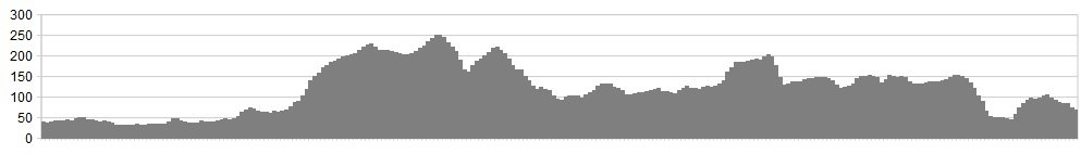
Stats: 38 miles and 2370 feet of ascent
OS Map: ![]()
Refreshments
Cafes at: Corbridge, Hexham, Bardon Mill, Haltwhistle, Greenhead, Gilsland, Lanercost, Brampton
Character
A ride through the countryside and through time! A glimpse into the occupation of Britain by the Roman Empire along the northern frontier of Hadrian’s Wall from the Roman fort town of Corbridge to Brampton.
Route
1. Leave the town centre and pass the Wheatsheaf pub on the s bend, then take a left turn onto Corchester Lane.
2. Follow this road as in winds its way toward the thriving medieval market town of Hexham, and enter the town through the industrial estate road and a left turn onto the bridge, take caution this is a busy road but is the only one into the town, then turn right at the roundabout and enter the park.
3. Cross the railway twice and follow the path along the river where you can see the joining of the North and South Tyne.
4. At the end turn right then cross the railway again, best to dismount as the road and rails cross at an angle giving this crossing a reputation for cycle crashes, and continue to Fourstones which was the site of the first official Boy Scout camp in 1908, then on to Newbrough and Stanegate which is the route of the original Roman military road alongside the Wall.
5. After the Stanegate rise, the top of which on a clear day can be seen Cross Fell in the Pennines and Cheviot in Northumberland, the road drops sharply on which take a right turn for the Vindolanda Roman fort excavation site.
6. After the fort follow the NCN 72 signs until you cross the A69 then take a right into Bardon Mill. Carry on along the old Carlisle road through the villages of Redburn and Melkridge to Haltwhistle, which occupies the geographical ‘Centre of Britain’. (Editor’s note – a claim hotly contested by Dunsop Bridge in Lancashire)
7. Turn right then left onto the main street, and again follow the NCN 72 signs out of the town until you meet the B6318, turn left then it’s a sharp descent into the village of Greenhead.
8. Take the first right for the wall fort of Gilsland, cross the bridge and turn left then take another left for Birdoswald which stands on the Roman fort of Banna.
9. Rejoin the route of Hadrian’s Wall, passing Bank’s East Turret, and on to Lanercost with its impressive Priory.
10. Cross the river Irthing and continue into Brampton.
click below for gpx file


