Satterthwaite Saunter
Route Information
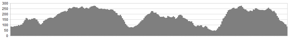
Stats: 23 miles and 2624 feet of ascent
OS Map: ![]()
Refreshments
Grizedale visitor centre has ample facilities. We can’t really speak for the pub at Satterthwaite, as it was closed recently when I went. It was okay years ago when last I went in. Hawkshead has some good spots, including a great little cafe near the Red Lion PH.
Parking is easy and free at the bottom of Moor Lane, just south of Satterthwaite.
Character
This route is excellent at all times of the year. There is lots of climbing involved, but some fantastic descents too, all on good firm tracks. It takes in the North Face Trail, and also allows the rider to exit and cut short the ride at various points, should the weather force a retreat. It skips around Hodge Close, giving you a taste of what’s on offer across that way, before climbing back up to the top of the forest and storming down Moor Lane to finish. Having ridden this recently, it’s a belter if you can handle the wet slate, which can take the wheel in unintended directions – be warned and have good winter tyres on the bike.
Route
1. Starting from the car parking area south of Satterthwaite, cycle up the road towards the Grizedale visitor centre. After approximately a mile, a turning off into the woods at Bogle Crag leads onto good forest tracks. Stay on this track as it winds its way above Bracken Wood, and a bridleway crosses the track, leading you down left and to the visitor centre.
2. Passing alongside the buildings and on the main tarmac road, turn right directly after the district forestry offices. A bridleway sign also leads this way, taking you to the start of the North Face Trail. At the end of this short lane is a 5 bar gate marking the track which goes uphill and into the forest (North Face Trail). This climbs steadily on a good surface, joining the forest tracks; turn right and cycle along for 100 yards befor turning onto the North Face Trail on the left.
3. Stay on the North Face Trail through this side of Grizedale. It initially climbs, twisting and turning uphill, with some tricky rock sections, but is easily rideable by most mtbers, including older children who have some experience.
4. We provide the Grizedale cycling map as a pdf at the foot of this page (or link to the right). Print it and take it along with you. Just after the section marked as ‘Topsy Turvy’, the trail rejoins the forest road/ track, and a bridleway to the left takes you down a steep and rocky track, all the way to Hawkshead. A small gate halfway down slows you slightly, but you can really enjoy the descent, letting the suspension take the strain as you pick your line.
5. At the bottom, turn left onto Barnfield, a small housing area, which leads out onto the B5285 towards Skelwith Bridge and Ambleside – unless you want to stop for tea and cake.
6. At the next junction (left), turn left, staying on the B5285, which is also signed towards ‘Brantwood’. After a couple of hundred yards a junction to the right leads onto Skinner How Lane. This narrow tarmac lane leads you onto the excellent tracks around Hodge Close area, and also keeps this a good year around ride.
7. At the next junction turn right and then almost immediately left up the lane/ track signed as a boat (byway open to all traffic) and ‘unsuitable for motor vehicles.’ This track rises and falls, passing Tarn Hows as you cycle across Arnside Intake, all the way out to ‘Mole End’ and the A593. Cross straight over the main road and cycle now along Smithy Brow, all the way to Hodge Close Quarries. If your legs have it in you, detour and circumnavigate Little Fell before rejoing the lane leading out of the quarries. The detour is worth it – trust me.
8. Rejoining the A593, turn right towards Coniston, then turning left into the bridleway at High Yewdale. This track leads all the way through to High Waterhead and another road. Turn right again and then left along the narrow road signed to Brantwood.
Opposite some white washed cottages, a bridleway on the left climbs steeply back into Grizedale. This can be tricky in places due to tired legs and rocky sections.
9. On reaching the high areas of the forest again, a crossroads of tracks becomes familiar. Head straight on and ride around the area known as Carron Crag (viewpoint), before re-joining the North Face Trail at ‘The Great Escape’, before this again brings you out onto forest tracks.
10. At the next T junction of tracks, a bridleway is signed straight ahead (creating a crossroads). This bridleway should be followed all the way to a junction of bridleways at the top of Parkamoor. Now turn onto the bridleway/ track to the left (Moor Lane), hang onto your pants and ride at speed all the way down to the finish of the route, crossing a couple of forest tracks on the way down. The upper sections have some technical elements, which can be slippery in the wet. It is after all a slate bedded track. It will test your line choices and bike balance, providing a superb finish to the days riding.
click below for gpx file


