Skiddaw
Route Information
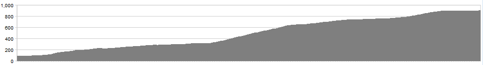
Stats: 4.5 miles each way 2700ft of elevation climbed to summit
OS Map: ![]()
Refreshments
The fleshpots of Keswick will cater to your every need. On the hill, though, you’re on your own.
Character
A pilgrimage to the summit of Northern Lakeland’s grand patriarch.
Route
The route comes in two sections – the wooded climb to the car park under Latrigg, then the more exposed haul up to the summit itself. Start in Keswick for maximum value. Leave on the A5271 Crosthwaite Road then turn right at the hospital onto the Brundholme Road then left onto Spooneygreen Lane.
Climb steadily then more sportingly through woodland to the Latrigg car park, memorising the bends as you go (you’ll be coming back ten times quicker).
Take the giant bridleway up and flanking left, riding as much as your legs and lungs will let you.
At the trig point, admire the views to north and south and then reverse your route.
click below for gpx file


