The Three Dales MTB Route
Route Information
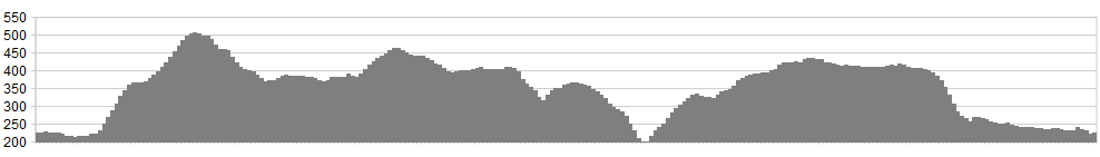
Stats: 24 miles (hard route) with 2500 feet of ascent
OS Map: ![]()
Refreshments
Limited at Arncliffe. Even the Falcon Inn PH has limited opening times; however, the landlord is a top guy and will make you a brew if you get caught out in a storm – as Taff and I found out! Nearby Litton has the Queens Arms, an award winning pub with a wider choice of opening times and fare on offer. Parking available at Arncliffe village in Littondale. Please park sensibly and consider local people. This is a small village
A great halfway halt is the Craven Heifer at Stainforth. It’s just as good now as it was 25 years ago when I worked at the nearby Youth Hostel (now closed). We had a map up of a 1/4 mile walk titled ‘The Craven Heifer Way’ – very popular with student field trips!
For a excellent choice head for Kettlewell, which would be a good base for a weekend riding trip.
Character
This route has its ups and downs – literally. Steep climbs on limestone meadows, rocky descents where ‘speed is your friend’ if well controlled, with the odd rolling section thrown in on the Pennine Bridleway. A steep road climb out of Stainforth is kept to the tarmac to make things easier,
Route
1. From Arncliffe head along the narrow walled lane back towards Kilnsey direction. At Arncliffe Cote take the bridleway signed on the right, through the farmyard towards the wooden 5 bar gate ahead. Climb the rocky track, passing through gates before the track wends its way right and left up the hillside.
2. Keeping the deep ravine to the left continue to climb the track that cuts through the steep meadow. The well-marked track eventually runs alongside a drystone wall (to your left) before twisting and climbing steeply left to the moor top. After crossing through a wall the descent begins, with the escarpment and trees surrounding Malham Tarn seen in the distance. Bending left the track becomes damp before exiting at Street Gate and Malham Tarn.
3. Follow the tarmac road with the Tarn to your right until a parking area is seen on the right. Shortly after this a bridleway on the left in the fence is taken. This crosses muddy ground intially before climbing on a good limestone meadow, exiting via a gap in the wall to the western side Malham Cove road.
4. Cross the road and take the Pennine Bridleway to Langcliffe. This well maintained track rolls along steadily before descending a rocky section of track to trees and the steep Langcliffe road at Cowside (OS Map).
5. Turn right and climb the steep bank for approximately 1 mile to the BW signed down to Stainforth. Ignore the first Pennine BW sign to Stainforth at 1/2 mile, as the descent is less interesting and the extra climb is worthwhile. This excellent rocky track twists significantly at the bottom and care is required on the loose surface. With good awareness and skill however, it’s an excellent descent.
Time for the Craven Heifer Pub!
6. Once refreshed head up the tarmac road that climbs steeply from Stainforth – Silverdale Road. Pass the junction right at 1 mile, ignoring this and continuing straight ahead. This testing tarmac continues for 4 miles with Pen Y Ghent for company to the left before descending to the bridleway on the right at Dawson Close (OS Map).
7. Take this bridleway, passing through gates and rolling along, passing over the Gill that drops sharply to your left, following which the track finally begins to descend. Passing through a gate the rocky track is walled in and enjoyed before a further gate causes the brakes to be engaged. Pass through this gate and continue downhill unimpeded to Litton, taking care not to get too carried away – in an air ambulance!
8. Take the walled track to the Littondale road and turn right, passing through Litton village on route back to Arncliffe.
click below for gpx file


