North Pennine 3 Counties Classic
Route Information
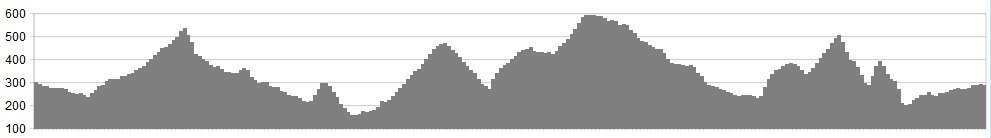
Stats: 77 miles and 6125 feet of ascent
OS Map: ![]()
Refreshments
Cafes at:
• Chatterbox in Saint John Chapel
• The Inn at Rookhope
• The Hemmel Cafe in Allenheads
• The Tea Rooms in Allendale Town
• The Village Pantry in Whitfield
• Blueberries in Alston
• West Natrass near Alston Golf course
• Langdon Beck Hotel at Langdon Beck
• High Force Waterfall visitor centre
• Bowlees visitor centre
• Cafe 1618, Rumours, Greggs, Fryer Tuck’s, Forresters, in Middleton
• Horn Hill Cafe, Dales Centre in Stanhope (requires a small detour).
Start and Finish: Saint John’s Chapel in Weardale.
Character
This is a long route, but is a good day out, or could even be broken in two; and is an exceptional way of seeing all of the best of the North Pennines but without any of the savage gradients the area is known for. Everything, until you leave Middleton, is long gradual climbs never exceeding about 5%. The initial few hundred yards out of Middleton, and the final climb of 3 over Bollihope, are a little steeper but are short, and Alston High Street is a challenge but also short, and because of the cobbles most will probably just push – the locals certainly do!
Route
1. Take what is labelled as a main road but is effectively not, out of SJC and pass through the quaint little villages of Daddry Shield and Westgate, turn left at the pub in Eastgate and head up the valley to Rookhope.
2. Carry on through the area’s clear former lead mining heritage passing derelict mines and farms up a very long but gradual incline until you reach the stone mound which marks the hill top, then a sharp almost alpine feeling drop into Allenheads.
3. Turn right at the crossroad and follow the road all the way to Allendale Town then on to Catton. Take a left turn which is signed for Staward, then left again at the end of the road and begin an exhilarating descent through tight hairpins with amazing views over the Allen Valley to meet the river at Cupola bridge, then continue on through the village of Whitfield and begin the long climb out of the valley.
Keeping an eye to your left, you are rewarded with increasingly impressive views of the valley and Pennines beyond, until you meet Alston Moor at the top. On a clear day, you can get your first glimpse of the summits of the high Pennines of Cross Fell and Great Dun Fell radar station.
4, Reward yourself with the long descent towards Alston, England’s highest market town, and turning left after the garage onto the High Street you will be forgiven for getting off to push up the entirely cobbled 15% incline!
5. As you leave the high street keep going and exit the town past the golf course, after a flat section with views of the Hartside pass on the right, begin another long but gentle climb up past the ski lifts to Burnhope Seat at an altitude of nearly 2000ft. Views again of Cross Fell to the right which still seems to be looming over, then begin nearly 18 miles of descent into the Teesdale valley through tiny picturesque villages and past High Force Waterfall to Middleton-in-Teesdale.
6. Turn left after the bridge and following the signs for Stanhope begin the three tiered climb onto Bollihope Common, the final descent of which goes down the wickedly tight hairpins of Unthank Bank.
7. Once you meet the river take the left turn signed for Brotherlee and follow the old road back along Weardale to Daddry Shield and a left to return to Saint John’s Chapel.
click below for gpx file


