Wold Newton
Route Information
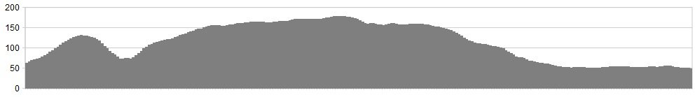
Stats: 10 miles and 650 feet of ascent
OS Map: ![]() Refreshments
Refreshments
Plenty of parking around the village of Wold Newton. The Anvil Arms serves lunchtime food Sat and Sunday and some evening meals. Advisable to check beforehand. Yorkshire Wolds Gallery has a café at Willerby Wold farm open Weds to Sunday 10am to 4pm.
Character
A 10 mile route along rolling lanes, starting and finishing at Wold Newton Village. 650 foot of ascent, to give you a taste of the riding in this great area. One for the family.
Route
1. From Wold Newton, take Front Street, which is the road in front of the white corner house opposite the duck pond. The road makes its way up and past the church on the right.
2. Carry on the long ascent, to the crossroads marked with a white signpost and go straight on past the Trig Point 133m on the right. Then start the descent down to Fordon; it’s narrow here, so watch out for oncoming vehicle. The road drops to the small Chapel before the crossroads and to the ‘Give Way’ line.
3. Take a left at the crossroads and through the small hamlet of Fordon, and up another hill to reach a flat section of road which you follow for just over a mile, to reach Willerby Wold Farm (refreshment stop). The bigs hills are over!
4. The road reaches a crossroad with the busy B1249. Go straight on at the crossroads and onto a rough road which drops to Ganton Wold Farm, and take a left at the junction and follow this road to Foxholes, meeting the B1249 once again. Take a right onto the B1249 sign posted to Langtoft and Driffield. Cycle the short distance and turn left onto the Meadows, and follow the road around to the right, and then a left to take the road back along to Wold Newton.
Usually a nice following wind at this point for the last few miles back to the start point.
click below for gpx file


