Above the Foxes Den
Route Information
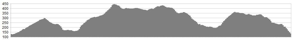
Stats: 15.5 miles & 2500 ft of ascent
OS Map: ![]()
Refreshments
Todmorden has a good choice of eateries, including great veggie options. Bikes shops in the area are renowned for their service, and the place is all around friendly. Nearby Youth Hostels provide cheap accommodation options, and the town has several B&B options as well.
Character
A route that climbs out of town to the Pennine Bridleway, taking in good double track and some excellent singletrack as it rolls up and down and around the valley. Nothing too technical and a great short spin for everyone.
Route
1. From the A646 Halifax Road, turn right onto Woodhouse Road, then crossing the small bridge by the old mill. Climb all the way to Lumbutts Road, turning right to the Shepherds Rest Inn.
2. From the Shepherds Rest Inn, follow the signs for the Pennine Bridleway south west. The track climbs and turns into large cobbled sets for 1km. Continue on Pennine Bridleway, down large cobbled sets for 0.8km. At the gate keep left and follow Hollingworth Lane uphill to gate and houses on the left.
3. Filter right off road and follow Pennine Bridleway on large cobbled sets for 1.7km. The bridleway exits through houses, turn right and fork right through gate and descend. At the canal bridge turn right onto towpath and follow for 1.4km.
4. At the Church on your right, turn left onto St Peters Avenue. At the crossroads head straight on to Inchfield Road opposite, climbing this epic steep road, and giving yourself a pat on the back if you clean it, then riding the continuation into Foul Clough Road, along the mixed track as it rises and skirts the hills, before climbing steeply again, all the way to the trig point.
Go through the gate and across the tricky ground now, where technical singletrack guides you down the valley and onto the double track of Limers gate (BW). Descend this all the way to the A646 road.
5. Turn down right to the A646 Bacup Road, and head right before dinking off left onto the indistinct and tricky to follow moorland bridleway that rolls along the moor beneath the wind farms, crossing Acre Nook Clough, as you head on singletrack to the junction with Tower Causeway – turn left here.
The road eventually turns into a track, which is followed for 1.4km. Take the right bridleway path uphill and continue north east for 0.8km to the trig point. This section can be overgrown at times and may require a short carry.
5. At the trig point go through the gate and take the right hand bridleway over moorland. After 0.5km follow the bridleway right off the moorland (this is easily missed).
6. The bridleway links into Limers Gate track, which is followed for 2.5km to the main road (A681). Turn left and follow A681 for 0.5km and turn right onto the track (Flower Scar Road OS Maps). Follow Flower Scar Road for 2.5kmincluding the descent to Flower Causeway. Turn left into Tower Causeway and follow for a further 2km. At junction turn right onto A646 and follow for 1km.
7. Turn left onto Pudsey Road, which climbs and becomes Shore New Road and follow as it climbs for 1.8km. Turn right onto the bridleway and fork left at the farmhouse.
8. Follow this bridleway south east ignoring all major right turns off the BW. It eventually becomes the track of Scraper Lane (by Gally Hall Farm), descending down to a junction, where you take the left hand track down through the golf course, joining the roads and heading back into town to finish.
click below for gpx file


