Loughrigg Loop
Route Information
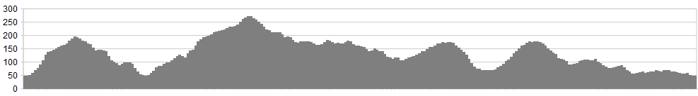
Stats: 14 miles and 2150 feet of ascent
OS Map: ![]()
Refreshments
Chesters at Skelwith Bridge are peerless for carbs – their granola slices will keep your thighs fuelled for hours. If thirsty, the Britannia Inn at Elterwater will give you a friendly welcome.
Character
If you don’t have a superb time on this route, whatever the weather, it may be time to have a long, hard, look in the mirror and ask yourself if you’re just a bit of a misery-guts.
This route is a gem, with stunning views, lip-smacking climbs and arse-smacking descents, and although Loughrigg Terrace will be mobbed with walkers taking the obligatory picture of Grasmere (and who can blame them? – I’ve done the same below) much of the route is surprisingly quiet considering its position at Lakeland’s heart. I’ve just ridden it on a midsummer day of sunshine and showers and seen no-one else in the saddle.
Route
1. If you’re up early enough, there’s roadside parking on the Under Loughrigg lane, near Clappersgate Bridge. Please park considerately and tuck in tight. [Failing that, there’s a car park at the north end of the lane.] From the bridge, ride north for 200m, taking the bridleway climbing up to the left.
2. Follow this line along the southern flank of Loughrigg Fell, coming down to Tarn Foot. Go down the lane, turning right (helpfully signposted to Skelwith Bridge) Turn immediately left (unhelpfully, not signposted at all) down the 1:4 past Neaum Crag campsite to Skelwith Bridge. Chesters is here.
3. Cross the bridge, bearing left into the lane marked “unsuitable for…” Then turn right on the Public Way.
4. Turn left at the road, go another 200m up the hill and take the well-marked bridleway on the left. A sporting climb ensues onto the high pasture of Iron Keld. Turn right (fingerpost to Tarn Hows) and right again, dropping back to the A593.
5. Cross the road, and take the lane up through juniper forest and creamy-scented bracken, then rattling down the slate to Hodge Close Quarry. Turn right here (signposted to Stang End)
6. At the end of the lane, bear left at the farm and skirt woods down to the foot- (and tyre-) bridge. There is a testing drop-off from this, and another at the end of the wall. Ride up the lane to the Wrynose road and turn left.
7. Turn right soon after, following signs promising “challenging option”. This promise is soon fulfilled with a rattly descent into Elterwater.
8. Bear slightly left at the village green and cross the main Langdale road. Climb up Red Bank to the Youth Hostel.
9. Go straight through the gate with the ornate handle into Deerbolt Woods, and traverse sensationally above the outflow from Grasmere. There are many paths here but the way should be reasonably obvious. When you meet the trees it zigs down to the left but climbs straight back onto the traverse line.
10. Go past sepulchral caves and a short descent that ranks with the Beast of Hope Cross for head-sized boulderiness.
11. Turn right at Under Loughrigg and trundle back to the start.
click below for gpx file


