Morpeth Deanery
Route Information
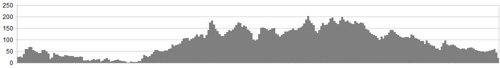
Stats: 76 miles and 3530 feet of ascent
OS Map: ![]()
Refreshments
Cafes at Newbiggin, Cresswell, Widdrington, Widdrington Station, Longhorsley, Kirkharle, Capheaton (only weekends), Belsay, Bolam, Stannington Station, Morpeth.
Character
A route based in Morpeth visiting the coast, the region’s former mining heritage, and some of the smaller less travelled areas of central Northumberland. The route is based on a longer charity ride taking in all 27 churches in the deanery of Morpeth.
Route
1. Starting from Morpeth, exit the town on the A197 (there is a cycle path on the right hand side) and at the top of Whorral Bank, go straight over the roundabout for Longhirst.
2. Passing Longhirst Hall then turn right at the church for Pegswood.
3. Enter the village at the school and continue past the former colliery rows to the junction and turn left.
4. At the roundabout (on which is a statue commemorating the village’s mining past entitled ‘Robin of Pegswood’) go straight on. Carry on through the ancient village of Bothal (look out for the Norman castle on the right) and up the bank.
5. At the end of the road turn right then first left, and left again after entering the housing estate. Carry on along Green Lane past the high school, straight on at the roundabout and right at the lights after the level crossing.
6. Take a left at the roundabout onto Newbiggin road.
7. Turn left for North Seaton Village and join the cycle path to underpass the dual carriageway and into Newbiggin.
8. Turn left in Newbiggin for Woodhorn, and right at the end. Enter Lynemouth and take a right turn to follow the coast to Cresswell. Keep going along the dunes past Druridge Bay and into Widdrington.
9. Take a left at the roundabout then right for Widdrington Station. Follow the road through the village of Ulgham (pronounced ‘Uff-um’) then a right.
10. Take a left for Cockle Park then right at Hebron. Cross the A1, then cross the A697 and follow the road along to a left turn at the junction.
11. Continue until a crossroad and turn right then on to Longhorsley. Turn left and continue to Netherwhitton, turn right then left.
12. Take the first left then a right signed Hartburn. Turn right at the end and go through the village and past Angerton Lake, carry on through Scots Gap to Cambo and turn left. Follow the road past Wallington House, cross the A696 to Kirkharle.
13. Turn left, left again then right, following the signs for Capheaton. Follow the road to the junction and turn left. After the zig-zags cross the A696, and turn left at the end just before Belsay.
14. Take a right, pass Bolam Lake, and right again through Bolam village, and on to Whalton. Turn left then a right for Shilvington. Turn left, then right then left again signed Stannington.
15. Turn right then right again and enter the village, turn left and carry on to the double roundabout to underpass the A1 then a right for Stannington Station.
16. At the end turn left and continue back to Morpeth.
click below for gpx file


