Rosthwaite to Grasmere
Route Information
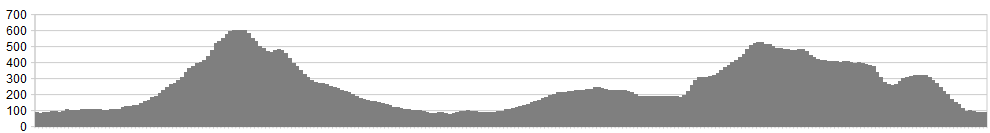
Stats: 17 miles and 3,700 feet of ascent
OS Map Link: ![]()
Refreshments
At Rosthwaite and Grasmere only. In between, there are you, the meadow pipits and the sheep.
Character
A tough crossing of two high, remote mountain passes, with long stretches of push’n’carry and a need for good navigation skills … and humour. You’ll also need good downhilling skills for the super techy finale down Hazel Bank.
Route
1. Head out of Rosthwaite towards Keswick but turn immediately right up the drive of Hazel Bank.
2. After the bridge, turn right again to the Stonethwaite valley. Follow this track, up the true right bank, for many a mile, ignoring the right turns up Langstrath. Climb steeply up Greenup Gill, shouldering the bike for a particularly steep section up Lining Crag, then heading for the slight col of Greenup Edge. This is an extremely confusing place in mist.
3. Flank across from Greenup on a broadly ESE bearing to the next col, just to the right of Calf Crag.
4. Set off doen Far Easedale, with many a pedal-snagging boulder to contend with. The track steadily improves, ultimately becoming a tarmac lane.
5. As you come into Grasmere, turn left into Helm Close, heading towards the Youth Hostel. Switchback along the flank of Helm Crag, turning left at the T-junction (don’t go right over the packhorse bridge.
6. Turn left where you meet the A591 and ride up Dunmail Raise. This is nowhere near as onerous as it sounds; the slope is short and not too steep and the carriageway is of such a commodious width that the traffic will tend to give you a decent berth.
7. At the top, where the carriageway splits, pick up a faint bridleway (little more than a sheep trod) shadowing the road on the left. Follow this down, bearing left to the farm.
8. Turn left at the minor road, and look out for the bridleway on the left, just after the prominent tor of Binka Stone.
9. For the next half an hour, your fate depends on forestry activity. Description may prove useless if new planting or felling has changed the terrain. Very broadly, your mission is to Go West, initially up the bracken-clad slopes on the true right bank of Dob Gill, then swapping sides at the outflow of Harrop Tarn. Expect a period of flailing through undergrowth before you emerge, scratched but triumphant, on the grassy slopes above the forest. Follow Mosshause Gill up to its source by the boundary.
10. Drop on peaty terrain to Blea Tarn. Follow the true right bank of the stream but not too closely – the track, sketchy as it is, skirts a steep slope above the stream, avoiding an impassable drop. When you get down to the 400m contour, the track veers dramatically left for a challenging descent into Watendlath.
11. Cross the outflow of Watendlath Tarn and take the good track leading up Bowdergate Gill. This short climb then reveals a gem of a descent – steep, rocky and utterly exhilarating. You’ve deserved it. Where the bridleway splits, keep left down to Hazel Bank.
click below for gpx file


