Coverdale High Road
Route Information
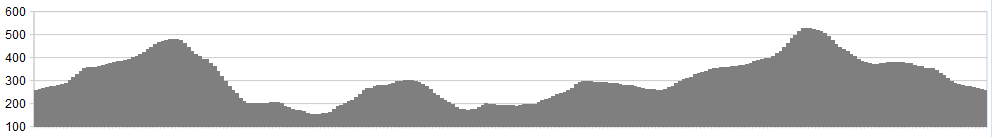
Stats: 15.4 miles (24.7 km)
OS Map Link: ![]()
Refreshments
The Foresters Arms, Carlton near Leyburn has 3 bedrooms if you need to stay over. They serve decent food and have a selection of ales from the Wensleydale Brewery. Nearby Leyburn has a wealth of cafes, shops and accommodation choices, being the centre for this part of the Dales. Middleham is somewhat smaller than Leyburn but well worth the visit for the pubs and an excellent chip shop to build up the calories after a ride.
Character
This is a cracking mid-morning or early evening ride over some fantastic Moorland. It has some superb steep and rocky Dales descents, as the route climbs and traverses the high ground to the southern edges of Wensleydale, taking you to some spots that the tourists miss. Coverdale is a spectacular area, close to Wensleydale, with high moorland and craggy fells. It’s one of those ‘out of the way’ areas that can almost guarantee a quiet ride.
If you fancy a full day’s entertainment, then link this in with the Bishopdale route beginning at Thoralby. This is a superb excursion and you’ll need to be fit. However, it will reward the effort.
The initial crossing from Carlton can be boggy in the middle section near the old Howden shooting lodge (see picture below). However, your perseverance is well rewarded with a superb descent to follow. The scenery on the descent is second to none. A steady climb follows this, before a trademark pedalnorth.com descent to finish off with.
Route
Note: The return leg utilises a track well worn by cyclists. However, if access becomes a poblem please let us know. It is your decision to walk or ride this leg. We cannot be held responsible for your own decision. If in doubt, take the BW further up the hill, to Penhill itself and descend to the shooting track and back.
1. Park in the village of Carlton, in the large car park in front of the village hall. Turn left out of the car park and along the road which bends to the right as you leave the village. A sharp bend to the left has a bridleway to the right. Take this and follow it as it twists and climbs on good ground to Howden Lodge, a desolated old shooting lodge which sits atop the boggy moor.
2. The path improves again quickly, climbing to a high point on the northern flanks of Harland Hill from where an expansive view overlooks West Burton on the other side of the valley. Enjoy the view – you’ll soon be rattling down the valley between Harland Hill and Heights of Hazely at a rate of knots. The path is smooth and fast, dropping sharply over rocky terrain on the lower slopes before rejoining tarmac at Whiterow Lane. Turn into West Burton village.
3. At the junction with the B6160 (The Grange B&B on the left) turn right towards Aysgarth. 150 yards ahead, a rising tarmac lane to the right of the B6160 should be taken, which turns right over a small packhorse bridge before climbing up to the left on a rocky track (Morpeth Gate). This track climbs through delightful scenery, with shady trees cooling you as you climb onto the high ground once more.
4. Morpeth Gate soon leads into High Lane, overlooking the dramatic sweep of Wensleydale. As the bridleway levels out, a metal field gate to the left of the bridleway leads through to a track which twists and turns all the way down to the A684 at Swinithwaite, passing the remains of a Knights Templar Preceptory on the way down. This is indeed historic ground. Ride along the A684 to West Witton, enjoying a break and a pint of Black Sheep at the Fox & Hounds. You’ll pass the Wensleydale Heifer on the way – in your state it’s too smart. Clean up and come back later and stay in its 4 star rooms! The beer and food is great at the Fox and Hounds.
5. Suitably refreshed, reverse the route along the A684 for 1/4 mile, taking Chantry bank on the left. Follow this as it climbs steadily above the village, passing a gated footpath to the right and continuing up on what now becomes Green Gate (OS maps). Tarmac gives way to a rocky track as you continue to ascend with drystone walls and field barns lining the way. Green Gate then becomes Nossil Lane, which twists and turns before re-joining the bridleway of High lane above Wensleydale. Turn left and continue along level ground all the way to the road at Witton Steeps.
6. As the climb eases and the road begins to level out, a track is signed to the right along Flint Lane. Take this track which eventually fades slightly as it reaches Penhill Quarry (disused). It then zig zags across the escarpment of Black Scar. Cross through the drystone wall, fasten your seat belts and join the excellent track which speeds you back down towards Carlton.
Keep your eyes peeled though – a junction to the right is required, lying by a spread of heather. Take this turning and continue the descent which will re-join the initial bridleway from Carlton village across the moor.
Now get yourself to the pub for a drink and a bite to eat.
Click below for gpx file

