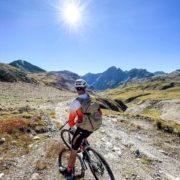
The Tour des Combins is a renowned route on the border between Switzerland and Italy, used by both hikers and bikers. It even has a website dedicated to it (which we link to below). Bikepacking in this area is tough but rewarding, with sections of hard climbing, bike hike and bike carrying. However, you’re rewarded by amazing views and extensive tracks that swoop down towards the valleys, as you traverse this sublime mountain area.

Route Information
Stats 115 km 4161 metres
Refreshments & Where to Stay
There are mountain huts along the way, and good options for small hotels and B&B slightly off route as you travel. You’ll maybe also want to spend the odd night under the stars. We’ve linked in to the wider expertise of the Tour des Combins website, to give you best information.
Click Here for official website
It’s also up to you to be sensible, and to take reasonable provisions and equipment with you on a Bikepacking trip such as this.
Character
This is a difficult route, and it should only be undertaken by experienced people with a good level of fitness, and people with good navigational skills. Don’t always rely on electronic devices to point your way; especially when high in the Alps. The hard sections are rewarded though, with swooping descents and technical trails that bring miles of smiles.
Route
The Tour des Combins begins at one of the great passes of the Alps – the Gran San Bernardo, in the heart of the Pennine Alps. It’s a tough and rewarding ride, which you’ll need at least three days to complete, and to add a few days more to, if you want a more relaxed trip.
Situated between the Mont Blanc massif and the Matterhorn, the route circumnavigates the slopes of the Combins bordering Italy and Switzerland. Accommodation options include the many mountains huts: COL DE MILLE HUT, BRUNET HUT, PANOSSIÈRE F-X BAGNOUD HUT, CHANRION HUT, and the LETEY HUT in Champillon.
It’s a mixture of epic singletrack, technical trails and easier tracks, with some hike a bike thrown into the mix, especially as you climb to the Fenêtre de Durand (2,797 m). Using elements of the ancient Via Francigena pilgrim trail, a 1800km medieval trail between Canterbury UK and Rome, it takes on the alpine valleys of Valle d’Aosta and Menouve, as it heads into coniferous woods, surrounded by the imposing peaks of Mont Vèlan, Gelè, and the Grand Combin. It is simply not worthwhile writing too detailed a route description here. Download the GPX file and have good maps and a compass with you and ensure that your navigation skills match your thirst for adventure.
However, here are a few short route tips. You initially climb on tracks, then descent to a point in the hills above the village of Creton, before climbing now to the high point of the route, on the border between Italy and Switzerland. From here you descend and can use the Cabane de Chanrion CAS as an overnight halt. The route then descends the vally to the village of Fionnay, before heading upwards again and into more forested hills, climbing and descending on epic tracks along the way, before a long climb to the Col de Mille and the refuge.
The route then descends towards the valley and Bourg Saint Pierre, before a final climb, passing Lac des Toules (Lake) as you head back to the Statua di San Bernardo.
Click below for GPX file
Download GPX