Drovers Way
Route Information
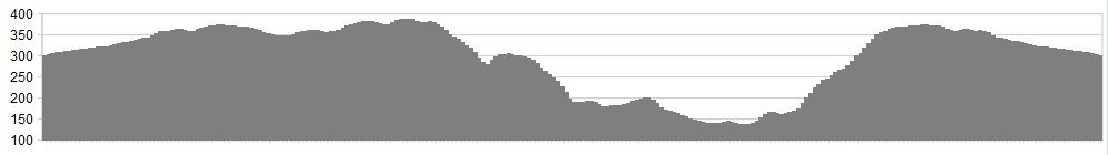
Stats: 13.5 miles 1271 ft of elevation
OS Map: ![]()
Refreshments
Pop into the National Park Centre for a coffee. On route, detour into Osmotherley, of if you choose the right time of the year and day, have a cream tea in Kepwick village. Nearby Helmsley or Thirsk are both great. You can also start this route at Sutton Bank, then joining the trail at Sneck Yate.
Character
This route follows the edge of the Hambleton Hills, along the ancient highway that links Sutton Bank with the picturesque village of Osmotherley. It rolls along with excellent views, before sweeping down steeply to ‘Square Corner’, followed by a fantastic descent through woodland – then a climb back to the ridge and home.
Park at Sneck Yate car park at the top of Boltby Bank, about 6 miles from Thirsk.
Route
1. We’ve started this route at Sneck Yate Bank car park rather than at Sutton Bank visitor centre. This way it makes the route a better all around ride for members of the family, and also leaves out some mundane elements.
From the car park, take the Cleveland Way as it follows a hard packed double track along the edge of fine moorland towards Osmotherley. This is shown as the ‘Hambleton Street’, passing along the dge of the Hambleton Hills.
2. Pass the track junction to High Paradise on your left, continuing straight on, with a gently rising and falling ride along good tracks. A gate is reached which leads into a wooded area, which provides some protection against winds (when they blow across the Moors), before again leaving the trees and cycling with moorland views.
3. The track along here is excellent at all times of the year, gently falling now as you pass by the track on the left (gated – Rag Robin Turn), before a more rocky and technical descent drops at speed towards the Forest of Silton and Square Corner.
4. As the track levels out at the junction of ‘Red Way’ to the left (signed through Forest), take the track to the left and enjoy a superb fast descent through Silton Woods.
5. Keep straight ahead as the track passes junctions left and right, and Red Way becomes Moor Lane. The woods are exited, and you can spot a car park in the trees to the right (useful for future trips), but stay on the now tarmaced road all the way to the T-junction at Kirk Ings Lane – turn left towards Kepwick.
6. After 1/3 of a mile another T-junction is reached – turn left again onto Lead lane, continuing on and passing the cul-de-sac junction of Thwaites lane to your left, as you enjoy some superb country lanes towards Kepwick. Stay on this road (Bridge Beck Lane, descending at speed as it twists and turns all the way to Kepwick.
7. After stopping and refreshing yourself – the village often has a cream tea or two advertised in the summer – head left and through the village westwards and back up to the Hambleton Hills along Rag Robin Turn. This is a steep and testing climb, but the track is excellent, being well drained sand and rock.
8. At the gate turn right and back onto Hambleton Street (the Cleveland Way), and follow your tracks all the way back to Sneck Yate, again enjoying the fine moorland track and short forested section.
The finale swoops down to the car park allowing you time to take in what is a fantastic introduction to what the area has to offer.
click below for gpx file

