Howgills MTB
Route Information
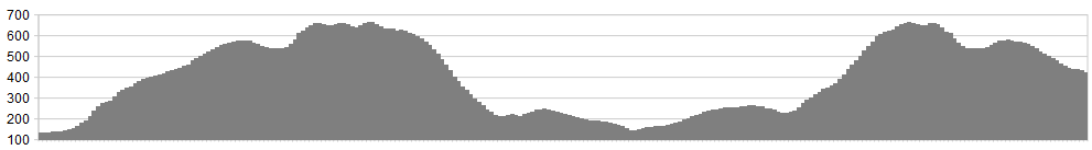
Stats: Stats 14 miles, 4680 feet of ascent
OS Map: ![]()
Refreshments
Car parking is available at Joss lane or Loftus Hill near the town centre. In the evenings you should be able to locate ample off-road parking. Ample tea rooms abound along the Main Street, and the local hostelries can be recommended. For those of you who have ventured out of Lakeland for the first time, Sedbergh is a delight and will surely draw you back again. The Howgills have some great accommodation alternatives, be it camping or bed and breakfast. Check it out at http://hiddenhowgills.co.uk/accom/self-catering.html
Character
I’d long since had a soft spot for the Howgills, but a chance mishearing suddenly endeared them to me even more. My daughter, then very young, pointed at the rolling swell on the horizon and asked, “Are those the Cowgirls, Dad?” From the mouths of babes comes praise indeed. The new name perfectly encapsulated their combination of undulating femininity and enticing wildness. So, in our family, they will forever be the Cowgirls. These hills provide an unparalleled riding experience – smooth surfaces, stunning views and a wealth of bridleways, with four distinct and legal ways to the tops. But, and this is a huge “but”, you will need lungs and you will need legs – three of each should about do it. Because the climbs are colossal.
Route
1. Leave the town on the road signposted to Howgill, past the People’s Hall, rising on tarmac until a concrete lane signposted “Permissive Path to the Fell” heads up to the right. Follow this to a farmyard and go up through a couple of gates.
2. At the intake, head up to the left until you reach a dry stream bed. Newton’s Fourth Law of Motion states that what goes zig must eventually go zag. Haul up alongside the stream bed until you find the shelving track skirting rightwards through the bracken. Follow this doggedly, rising in an anti-clockwise spiral round the shoulder of Winder. Keep going up the ridge then take the right fork up the flank of Arant Haw. As you climb, memorise all the little steps you’ll be catching air on when you come back down.
But, for now, there’s just a short, rattly descent to a col before the pull onto Brant Fell, starting steep and getting progressively steeper and looser. Newton’s fourth applies again – zag to the right. The Calf is now just a couple of swoops away on a gravelly track.
3. Take a moment to admire the views from this vantage point between Lakes and Dales. Then strap yourself in for the plummet down the flank of White Fell (parachute optional). The descent starts blithely enough – skirting north-west, then south-west, round the declivity of Calf Beck. Then the ridge just falls away and a little thing called gravity get its mitts on you. Fortunately, the surface is smooth and the way is straight, so a point-and-hope approach may just be see you down.
4. Splash through Long Rigg Beck and keep going on a slightly climbing track that drops down to the road. Turn left and follow tarmac down into Chapel Gill and out again. Turn left on a farm track to Birkhaw and keep going, with another splash through Bram Rigg Beck.
5. Your mission now, whether you choose to accept it or not, is to ride as far as you can up Bram Rigg itself, clawing for every litre of Cumbrian air you can lay your lungs on. The last stretch dinks left to the main ridge and you’re back on known territory.
(5a. For a longer version – ride back up the Calf trig point and sample the bucking descent north-east, followed by the long descent of Bowderdale. Then haul yourself back up to the Calf for the Grand Finale. That is, if you’re up to three big climbs.)
6. The way south from the top of the Howgills has to be the most fun descent anywhere. Apart from a slight pull onto Arant Haw, the only way is down, down and down. Trust me – this is as much fun as you will ever have with your Lycra on. Because Cowgirls know how to show you a good time, right?
Click below for gpx file

