Ingleborough Round
Route Information
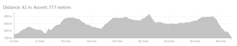
Stats: 26.6 miles OS map: ![]()
Refreshments Both Ingleton and Clapham have excellent facilities. For me, Ingleton scrapes it for the cafes, with a wide variety. The cafe above Inglesport is excellent, and ‘Bernies’ on the High Street has good portions that’ll fill you up, whilst being a bit more welcoming to muddied up mountain bikers. We’ve started this route at Ingleton, where there is an excellent Youth Hostel, and a good selection of bed and breakfast accommodation.
Character This is a hard route, with some steep climbing and good rolling descents. Although not our hardest route, it covers some rough ground and takes you into the real Dales, as you circumnavigate Ingleborough, so make sure that your map reading skills are up to speed. It can get warm out in the hills in the summer months, so take plenty of water on this route. There are few places to stop and refresh. The best option is the Three Peaks Cafe at Horton in Ribblesdale. Like all good rides, it finishes on a downhill.
Route
1. Turn left out of the car park and follow the minor road signed for Clapham. This is a 5km stretch of tarmac to warm up along.
2. At Clapham turn left into Eggshell Lane and then into Church Lane, crossing the bridge. At the end of the churchyard turn left, heading for the tunnels and Austwick (signed), before turning left at a junction onto Long Lane (bridleway).
3. (Grid SD750694) Follow Long Lane to a gate onto Moorland, bearing slightly right and following the grassy track. Go through another gate and keep right to keep the high point to your left. Continue to a concrete plinth, turning left and then right and onto another plinth. The bridleway is well signed all the way past Long Scar and across limestone countryside to a track ‘X’ roads at Sulber, where you continue along the bridleway north, ahead towards Borrins where it twists right and down to the tarmac lane.
4. Once on tarmac, head south along the lane and into Horton in Ribblesdale, continuing through the village, over the bridge to the Crown Inn. Now is the chance for a brew at the nearby Three Peaks Cafe, or continue by turning left and alongside the Crown to the bridleway signed ‘Pennine Way’ and ‘Ribble Way’ which eventually lead you past Sell Gill Holes.
5. After 6km of this bridleway a junction of bridleways is reached. Take the left hand fork, down to Ing Gill. This track is signed as part of the Pennine Way, so continue on this until you reach Ling Gill Bridge. Go over the bridge and turn right on the track, continuing on it until the junction with the Dales Way. Turn left and head towards Ribblehead.
6. At the Ribblehead road junction a van is usually parked up which serves teas etc. Make use of this before the next short but steep climb, from the road, follow the track (signed bridleway) which leads off towards the viaduct, going below the arches to Gunnerfleet Farm. Go around buildings to a ‘T’ junction, turning right and on to another junction (bridleway), turning left (Scar End), keeping on the track until it breaks right Go through a gate on the left, through fields to a waymark that directs you right. This track will lead you all the way to Ellerbeck Gill.
7. A vague and boggy track in the wet now leads for some 3 km, all the way to limestone pavement above Twistleton Scar. When you reach the notch in the Scar (edge) enjoy a twisting descent all the way to Scar End and tarmac.
8. Now follow the roads all the way back to Ingleton and beans on toast at Bernies.
Click below for gpx

