Kendal Eight
Route Information
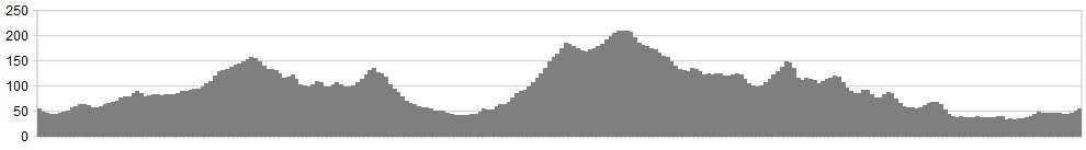
Stats: 21 miles and 1765 feet of ascent
OS Map: ![]()
Refreshments
Spoilt for choice in Kendal
Character
The wedge of land between the Lakes and Dales is an inexplicably quiet backwater. It would merit the phrase “best-kept secret” if that weren’t so obviously oxymoronic. Even when the proposed extensions to the National Parks take place, the area of this ride is likely to remain resolutely overlooked. And long may it remain so.
The majority of the route is down narrow country lanes that you’re likely to have to yourself. The first part of the ride shadows the M6 but you wouldn’t know it’s there as it’s hidden from sight and the sound (at least while the wind is in the western quadrant) isn’t an issue. The only road noise is from the A590 down near Tewitfield.
The start point is described from a motorist’s point-of-view but the route passes Oxenholme station so it would be perfectly possible to approach it by rail.
Route
1. From the layby, set off on the A65 north, towards Kendal for ¼mile, passing under the motorway.
2. Turn right into a narrow lane signed “Friends’ Meeting House, Goose Green“
3. Follow this for around three miles until you meet the B6254 at Old Hutton. Turn Left.
4. Follow the B road past Oxenholme station down towards Kendal.
5. Rejoin the A65 at a set of traffic lights and continue into the town.
6. At the big roundabout, take the third exit into Lound Road. The River Kent is on your left.
7. With the museum on your left, turn right at some lights into Park Side Road.
8. Climb to the A684 and turn right towards Sedbergh. Keep climbing, past a transmission mast.
9. Just after the brow, turn right into a tiny road called Hawkrigg Lane.
10. Drop down this, swinging right (look out for mud on the road) until you reach Beehive Lane.
11. Turn left, and go down to the B6254 again. Turn right. If things look oddly familiar, that’s because they are.
12. This time, you’re looking for a ludicrously well-hidden left turn. It is completely unmarked, doubles back and looks more like a farm track than part of the public highway. But trust me on this. It’s as you’re climbing, just after the sign warning of horse-riders.
13. Follow this lane, skirting the low ridge of The Helm, then dropping to the A65 at the Punch Bowl Inn.
14. With all due care, cross the A65 into the lane opposite.
15. Turn left at the next junction, ignoring the National Cycle Route 6 going right.
16. Head sound on a charming lane. Watch out for a crossroads (No Give Way sign) by a small graveyard. Try not to join them, yes? Go straight over, past Crosscrake Primary School.
17. Go over the small humpback bridge round the terminus of the canal.
18. Keep heading SSE, parallel to the A590. When you reach the B6385, turn left. At the A65, turn right to return to the start.
Click below for gpx file

