
 Tobias Arweiler
https://pedalnorth.com/wp-content/uploads/2026/03/tobias-arweiler-wHnUcwgTxKQ-unsplash.jpg
1106
1920
Pedalnorth Website
https://pedalnorth.com/wp-content/uploads/2026/02/Pedalnorth-final-logo-and-wording-for-February-2026.svg
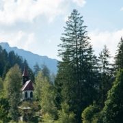
Pedalnorth Website2026-03-05 12:18:482026-03-05 12:22:53Schattwald and the Tannheim Valley gravel ride – in the Austrian Tyrol
Tobias Arweiler
https://pedalnorth.com/wp-content/uploads/2026/03/tobias-arweiler-wHnUcwgTxKQ-unsplash.jpg
1106
1920
Pedalnorth Website
https://pedalnorth.com/wp-content/uploads/2026/02/Pedalnorth-final-logo-and-wording-for-February-2026.svg
Pedalnorth Website2026-03-05 12:18:482026-03-05 12:22:53Schattwald and the Tannheim Valley gravel ride – in the Austrian TyrolThis is a bit of a mundane day. The tracks start and finish with interest, but there’s a section in the middle along lanes which goes on for some time on tarmac. This will however speed you along to the North Yorkshire Moors and Osmotherley. We’ve looked at this link for some time and didn’t want to take you off road just for the sake of it. Some of the trails above Northallerton can be really muddy and overgrown after poor weather, as they’re little used. If it is damp, then stick to the quieter lanes until you cross the A19 road and reach the Moors. If the weather has been damp and there’s a likelihood of muddy tracks across the Vale of York, then simply stay on the quiet lanes and avoid the listed bridleways across the Vale. Overall, it’s your choice, and we leave the option open to you.
Grinton is a given on this C2C, as is Osmotherley, for the fantastic riding that they provide. So today is the best link we could find. It does have some interesting little sections of off-road, that help to provide the link, but that will also give you a taster for a return trip to do them as a loop.
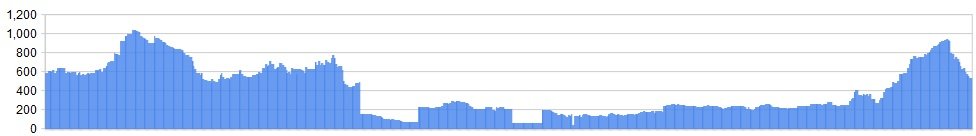
Distance: 42 miles
Ascent: 2756 ft
OS Map:  Character
The mileage is high, but it is along flat and quiet lanes in the main, so you’ll find it quite relaxing and easy. You’ll have built up some stamina and fitness by now, and this will be a good day to have a bit of a break in the saddle before the Moors. The climbing on this day is limited to the off road sections wherever we can make it, giving as much interest as possible. Even Wainwright had problems linking this section.
The final ride from Scarth Nick does provide some interest, and if you’ve got time, you can explore some more before heading down into Osmotherley.
Route
1. It’s now time to leave the Yorkshire Dales. Two National Parks completed and one to go. Hopefully you’ll be back for more adventurous riding in the future. For now, leave the Dales Cycle Centre at Low Fremington, turning Left onto the Reeth Road. After 80 metres a junction is taken to the Right. This narrow lane traverses above the River Swale to Marrick Priory on a metalled road.
2. 100 metres past the priory the BW passes through a farmyard before beginning the climb above small woodland. The track then skirts above woodland before heading up and left, crossing fields on its way to Marrick village. This wide dirt doubletrack eventually eases and joins Ellerholme Lane, a rockier track. After 200 metres a track junction is reached. Turn Right. The narrow walled lane twists around to the left before a junction by a telephone box. Turn Right and stay on this road as it turns sharply left and climbs steeply with rolling sheep meadows either side. The road soon levels out as you continue along to Nun Cote Nook Farm on the Right of a left hand bend.
3. The BW is signed to the Right of the farm entrance, through a large 5 bar gate. This excellent rocky dirt track rolls across Croft How for 1 mile, before the track descends and snakes down passed farm buildings to Low Oxque ½ mile further on. At the track junction, through the farm entrance, Turn Left. Follow this track as is falls down to the road ¾ mile further on.
Turn Left and climb steeply on the road (Cat Bank) for 1 mile as it zig zags up to Marske. At the road junction on the edge of Marske turn Right (signed Washton / Ravensworth – and coast to coast on foot!). This twisting lane climbs steadily, soon passing the churchyard on the left.
4. The road (Clapgate Bank) continues uphill for a further mile before a BW is signed on the Right, below Applegarth Scar—scene of some dodgy rock climbing by the pedalnorth team some years ago! Today though, we’re just cycling beneath it. Take this excellent track and roll along easily for 3 miles, through rocky meadows and trees, before a metalled road is reached. The BW eventually drops down, depositing you in historic Richmond.
5. Once refreshed, leave Richmond on the B6108 towards Skeeby, less than a mile away. At the edge of the village, and just before The Travellers Rest PH, a BW to the Right is seen. Take this. The track climbs gently alongside cottages to a gate, before crossing fields on an excellent double track, exiting eventually by Bark Farm, on the road at Parkgate Lane near Brompton.
Note: from here on in, across the Vale of York and to Osmotherley, some of the listed bridleways can be muddy, overgrown and annoying. We’re not in charge of maintaining them and you have to accept that they may be muddy and overgrown. In bad weather, or following bad weather, you may be better sticking on the quiet lanes to Osmotherley – it’s your choice.
6. Turn Left and follow the B6271 road through Brompton, passing underneath the A1 to Catterick Bridge. ¼ Mile after passing under the A1 road a crossroads with traffic lights is reached. Turn Left.
1 mile along this road a large entrance to the Right shows a lane/ track (BW) which should be taken. This BW passes large farm buildings at High Gatherley after ¼ mile, before heading on to Gatherley Grange at ¾ mile. Here a ramshackle farm is seen and the BW takes the Left side of the farm buildings before turning Right around it’s boundary and rolling along the edge of ploughed fields.
½ mile after passing Gatherley Grange, the track passes through scrubland before easing alongside more fields on route to Uckerby. However, as the road comes into sight and the track seemingly heads straight on to join it, the BW doglegs Left and then Right, with white washed cottages eventually seen to the Left as the track descends to the road at Uckerby.
7. Cross straight over the road, taking the BW (lane and cul de sac) opposite, alongside cattle sheds and barns to the right. This metalled road rises gently with hedgerows either side, before the tarmacked surface gives way to a hard packed track. 1 mile after leaving Uckerby a small woodland to the left (Uckerby Fox Covert on maps) is seen and passed on your Left. The track gently rolls you down then to North Cowton and a quiet country lane. Turn Right and cycle into the village. As the village green is seen on the Left and the road rolls down and around to the Right, follow the road, passing the Blacksmith’s Arms on the Right and cycling on to the crossroads with the B1263.
8. Go straight over the B1263, through East Cowton, before cycling downhill and under the railway ¼ mile on from East Cowton. ½ mile further along this twisting lane, pass by and ignore the very minor junction to your Left, climbing for a further ¼ mile to the BW on the Right. Signed ‘Frigidale Farm’ take this track. After ¾ mile a BW junction is passed at Birkby Farm. Stay on the wide and good metalled track that rolls down to the A167 at Little Smeaton – turn Right.
9. 1 mile further on turn Left onto Deighton Lane (signed: Deighton / Welbury) and cycle all the way to Deighton village. Turn Left at the T Junction (signed Appleton Wiske) and follow this lane for ½ mile, then taking the BW (gap in hedgerow) to Welbury. Careful navigation is required here as the BW splits almost immediately and the more obvious track to the Left should be taken, rolling you along between the high hedgerows before exiting onto the tarmac at Welbury village.
10. Turn Right and cycle along the lane, passing through Welbury village, to the T junction near the level crossing. Turn Left and cross the railway line with care. ¼ along this country lane a wide gated farm entrance to the Left (BW) should be taken, leading you along a tarmacked track (Green Lane on maps) to South View. As the track bends left, stay on the BW straight ahead, now a good hard packed track as the BW edges alongside meadow and wheat fields, before exiting at a metal gate onto yet another quiet country lane.
11. As you enter this road, a junction slightly Right and almost opposite is signed to East Rounton and Teesside. Take this lane to the road junction in the village. At the junction turn Right signed to Thirsk / Teesside A19. ¼ mile along this road, a BW is seen to the Right, heading off on a double track through trees towards the A19 and Ingleby Arncliffe.
Nearly there now guys, so keep going. We’ve made this crossing of the Vale of York as tarmac free and interesting as we possibly can. However, even the great man, Wainwright had difficulty achieving this.
12. As this track drops down to the A19 take care to stop before crossing this dual carriageway. There is a central reservation area for turning traffic. Please use this and cross each carriageway separately. A narrow hedge lined country lane opposite leads off the A19 to Ingleby Arncliffe. This lane ends at a T junction with a stone tower opposite to the right. Turn Left at this junction.
13. A further junction is reached in 50 yards. Turn Right and cycle away from the village towards the A172. At the crossroads with the stone cross on the right, Turn Left. Follow this lane until it joins the A172. Turn Left and cycle along the A172 with care until a BW is seen on the Right after 100 yards. Take this good grassed doubletrack which leads up to Scarth Wood, twisting left towards the nearby farm, where the track gradually improves before continuing on and above Scarth Lees. This stony track, which twists and turns, speeds you down to the road, providing some respite before some climbing begins.
14. Turn Right. This narrow single track road (Back Lane) climbs steeply to a junction with Coalmire Lane – Turn Right The lane continues climbing, eventually crossing a cattle grid and joining moorland at Scarth Nick. A BW (Cleveland Way) to the Right of the cattle grid should be taken. This track climbs with difficulty on laid stone flags, crossing Scarth Wood Moor as you ascend towards Arncliffe Wood. For future trips, the moorland track that you’re now struggling up forms part of other pedalnorth.com routes, taking the friendlier direction by descending at speed.
However, you can come back another day for that delight. For now, climb to the woodland, where a small kissing gate leads through to a continuation of the BW on an excellent doubletrack that speeds down through fields to a metalled track which continues the arrow straight descent to the road. Turn Right at the road.
15. Now it’s time to visit the Queen Catherine Inn and settle down with some fine food and refreshments. Another day done and tomorrow it’s the North Yorkshire Moors proper and some sweet singletrack.
Click below for gpx file & accommodation

RELATED CONTENT
Tobias Arweiler
https://pedalnorth.com/wp-content/uploads/2026/03/tobias-arweiler-wHnUcwgTxKQ-unsplash.jpg
1106
1920
Pedalnorth Website
https://pedalnorth.com/wp-content/uploads/2026/02/Pedalnorth-final-logo-and-wording-for-February-2026.svg
Pedalnorth Website2026-03-05 12:18:482026-03-05 12:22:53Schattwald and the Tannheim Valley gravel ride – in the Austrian Tyrol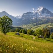 https://pedalnorth.com/wp-content/uploads/2025/10/Grindelwald-and-Eiger-image-by-davidbirri-22d0xgfemt7366w.jpg
1708
2560
Pedalnorth Website
https://pedalnorth.com/wp-content/uploads/2026/02/Pedalnorth-final-logo-and-wording-for-February-2026.svg
Pedalnorth Website2025-10-13 16:07:232025-10-13 16:32:51Grindelwald Eiger Gravel Epic Route
https://pedalnorth.com/wp-content/uploads/2025/10/Grindelwald-and-Eiger-image-by-davidbirri-22d0xgfemt7366w.jpg
1708
2560
Pedalnorth Website
https://pedalnorth.com/wp-content/uploads/2026/02/Pedalnorth-final-logo-and-wording-for-February-2026.svg
Pedalnorth Website2025-10-13 16:07:232025-10-13 16:32:51Grindelwald Eiger Gravel Epic Route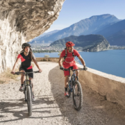 https://pedalnorth.com/wp-content/uploads/2025/09/Tremalzo-MTB-round-tour-Garda-website.webp
1164
1920
Pedalnorth Website
https://pedalnorth.com/wp-content/uploads/2026/02/Pedalnorth-final-logo-and-wording-for-February-2026.svg
Pedalnorth Website2025-09-11 20:35:432025-09-15 09:43:32Italy and the Tremalzo MTB tour
https://pedalnorth.com/wp-content/uploads/2025/09/Tremalzo-MTB-round-tour-Garda-website.webp
1164
1920
Pedalnorth Website
https://pedalnorth.com/wp-content/uploads/2026/02/Pedalnorth-final-logo-and-wording-for-February-2026.svg
Pedalnorth Website2025-09-11 20:35:432025-09-15 09:43:32Italy and the Tremalzo MTB tour https://pedalnorth.com/wp-content/uploads/2025/09/Alex-on-Stelvio-mtb-route-2025-.jpg
1920
1440
Pedalnorth Website
https://pedalnorth.com/wp-content/uploads/2026/02/Pedalnorth-final-logo-and-wording-for-February-2026.svg
Pedalnorth Website2025-09-08 16:01:012025-09-09 09:23:03Stelvio Pass gravel and mountain bike route – unpaved
https://pedalnorth.com/wp-content/uploads/2025/09/Alex-on-Stelvio-mtb-route-2025-.jpg
1920
1440
Pedalnorth Website
https://pedalnorth.com/wp-content/uploads/2026/02/Pedalnorth-final-logo-and-wording-for-February-2026.svg
Pedalnorth Website2025-09-08 16:01:012025-09-09 09:23:03Stelvio Pass gravel and mountain bike route – unpavedKIT PARTNER
TECHNOLOGY
Tech Partner
Road Bikes
Off Road
Bike Packing
Life Cycle E-Mag
