
 Tobias Arweiler
https://pedalnorth.com/wp-content/uploads/2026/03/tobias-arweiler-wHnUcwgTxKQ-unsplash.jpg
1106
1920
Pedalnorth Website
https://pedalnorth.com/wp-content/uploads/2026/02/Pedalnorth-final-logo-and-wording-for-February-2026.svg
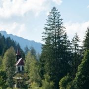
Pedalnorth Website2026-03-05 12:18:482026-03-05 12:22:53Schattwald and the Tannheim Valley gravel ride – in the Austrian Tyrol
Tobias Arweiler
https://pedalnorth.com/wp-content/uploads/2026/03/tobias-arweiler-wHnUcwgTxKQ-unsplash.jpg
1106
1920
Pedalnorth Website
https://pedalnorth.com/wp-content/uploads/2026/02/Pedalnorth-final-logo-and-wording-for-February-2026.svg
Pedalnorth Website2026-03-05 12:18:482026-03-05 12:22:53Schattwald and the Tannheim Valley gravel ride – in the Austrian TyrolOpen moorland, steep climbs and steep descents, with added technicality; this is a hard day in the saddle, but it weaves together some of the best tracks in the area. Very few road sections and these will be welcome when they arrive.
You’ll need to have your eyes open today, as the singletrack BWs can be tricky to locate and can be easily missed. This is a day of climbing; yep, it has some great descents, but these are earned through hard graft and lots of pedaling. Take care on the rocky descents. They can be tricky if you’re not used to tight and rocky singletrack. Corners can and will catch you unawares and big rocks and twitchy drops wil come out of knowhere. This is after all ‘mountain biking
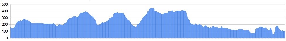
Distance: 45.6 miles
Ascent: 4855 ft
OS Map:  Character
Pack plenty of supplies, because there’s very little opportunity for tea stops on this stage. Make sure you’ve got tools and tubes with you. We’ve recently amended this section after feedback, now using the Ironstone Railway to speed you to Rosedale and the Lion Inn, then taking some excellent singletrack to Dalby Forest. You can stay near Dalby Forest, then heading straight onto the trails for the final day!
By now you should be fit and raring to go across the North Yorks Moors. Good, because today has some epic climbs. They are however rewarded with some epic descents.
Yesterday provided a bit of a rest as you traversed from Grinton to Osmotherley. We’ve chosen Osmotherley because it has a wealth of accommodation, including a good Youth Hostel and a campsite, enough drinking haunts and even a chip shop. The route from here also brings in a great example of NY Moors riding: steep climbs on good tracks, great moorland riding and some epic descents on firm ground to build up the speed. We fixed on this stage after some feedback, together with some great advice from Steven Tilly, who suggested the Cold Moor descent be included, describing it as follows:
“The terrain varies as you proceed down the descent, it starts off quite rocky with some nice little drops and hazards, becomes a bit more rutted and gully-like further down before opening up into a wider more grassy finale. When you eventually reach the wall, you follow the track parallel to the wall (passing through 2 or 3 gates on the way) down into Chop Gate itself. This track is also fun & fairly fast, though not so demanding.”
Later on during your moorland journey, you’ll have some of the finest singletrack anywhere in the UK, as you ride around Rosedale and head to Dalby Forest. For now though, you need to concentrate on the climbing today, and traversing of wild moorland. By the time that you arrive at Rosedale Abbey you’ll be tired but pleased with yourself and the ride. Just one more day to go, so have a drink… you’ve earned it.
Route
1. From Osmotherley head out of the village towards Hawnby and Square Corner. Approximately 1km past Square Corner on the Right, take the BW (bridleway) that leads down and past ruined farm buildings at Dale Head, along testing singletrack before a descent to the road at Locker Wood.
2. Turn Left at the road and climb steeply to Low Cote Farm, leaving the road again for the BW that climbs Arnsgill Ridge. At the BW junction on the sandy moorland tracks stay Left and follow this sandy track as it heads above Scugdale before descending to the tarmac near Crossletts Farm. There is a stone / concrete water trough in the heather just off the track junction in front of you as the track heads off left.
Turn Right then Left up the lane which climbs to Cold Moor and Raisedale. This excursion can be omitted but takes in one the great descents of the North Yorkshire Moors.
3. At the top of Bleak Hills there is a multitude of tracks converging. Take the BW which drops steeply at speed, across excellent technical terrain to Chop Gate.
4. At the B1257 road turn Left then Right, ascending the quiet lane towards Bilsdale Hall (shown on OS mapping). A sign on the main road opposite the junction indicates ‘St Hildas Church’ – if unsure this will aid you. There is also a small red post box at in the hedge to the left of this lane by a village notice board.
5. Follow the lane as it weaves uphill to buildings at Bilsdale Hall. Immediately prior to the hall, a 5 bar gate is seen set back on the right, with a BW sign to the left of the gate. Go through the gate here and follow the track as it ascends to the moor. Continue ascending the good track for 1.5 mile, when you join a junction with the Cleveland Way – turn right.
Having now evened out, the track continues for a further 1.6 miles, before crossing another junction of tracks at Bloworth crossing. This puts you safely on the trackbed of the old Ironstone Railway, which will weave you across the moors safely to Blakey Ridge and the Lion Inn some 5 miles further along.
On reaching the Lion Inn, a minor track leads off to the left before the main track joins the road, providing a short cut as you head for the road and some Rosedale singletrack. However, This is the famous halt on the Like Wake Walk, a 42 mile hike across the moors. It’s also on Wainwrights Coast to Coast Walk, and the staff are used to serving tired souls good grub, so a midday stop may be a good decision.
6. Once refreshed, head up the road (Left), before taking the indistinct singletrack BW that cuts across the heather moor to the road on the opposite side of the valley. This can be tricky and technical, but great fun. Once at the road again, Turn Right and stay on the road until the BW is reached on the Right, which goes over the moor and drops down to the Ironstone Railway and Dale Head Farm. Once again, this is a technical track and care should be taken.
Whilst a permissive cycle track exists around the old Ironstone Railway, it is not intended for mass use. This is an active Grouse Moor that is managed and maintained by the landowner. Please respect this, and keep to the BW that we have indicated.
7. Cross over the Ironstone Railway track and drop down beside trees to Dale Head Farm, then picking up the metalled road that twists into the valley. A few hundred yards on, a BW is seen up a track on the Right – take this. Follow this BW until it rejoins tarmac at Thorgill, then heading to Rosedale Bank and the village. You can take tea and a break, or stay overnight here before a long final day tomorrow via Dalby.
We’re heading onward though, towards the world renowned mountain bike centre at Dalby Forest.
8. Now to head to the coast, taking in some great forestry riding at Dalby on route. But first we have some more of the best singletrack in the UK on offer. Climb Rosedale Bank to the hotel. You may need to walk up this! It’s England’s steepest road! Take the bridleway off to the left, passing Bank Farm and a cattle grid on route to the bridleway junction at Hollins Farm. Take the singletrack that skirts the edge of the moor undulating along superb moorland riding until it eventually gives way to a track which leads to tarmac at Lower Askew.
9. Follow the road down to Cropton, then turning left at the village green and following the narrow lane signed for ‘Sutherland’ and ‘Newton’. Approximately 2.2 miles along this lane, the road turns sharp left, with a cul-de sac directly ahead. Stay ‘straight ahead’ following the rough track of the culde sac for a further 0.7 miles.
10. A short distance further on a ‘T junction’ track is reached – turn down right and follow this track until it joins the main road by Yatts Farm. Turn left and immediately right, into Ruddings Road, a hedgerow lined flat lane that will speed you along towards Dalby. A crossroads of tracks is reached next. Go straight on, following this track as it crosses the North Yorks Moors Heritage Railway, turning right almost immediately once across the tracks, skirting left as a copse of trees is reached, following the BW with the trees now to your right, then across to meadow towards Crossdale Road (track). A reassuring sight will be Farfields Farm bed and breakfast to your left (a possible overnight stay) – and you’ll be staying directly on the route!
Failing this overnight option, continue to the road, crossing to the Fox and Rabbit Inn opposite. This is Dalby Forest country, and we recommend that you stop here, before heading into the forest the next day. It’s been a long haul and you’ll need a rest.
Click below for gpx file & accommodation

RELATED CONTENT
Tobias Arweiler
https://pedalnorth.com/wp-content/uploads/2026/03/tobias-arweiler-wHnUcwgTxKQ-unsplash.jpg
1106
1920
Pedalnorth Website
https://pedalnorth.com/wp-content/uploads/2026/02/Pedalnorth-final-logo-and-wording-for-February-2026.svg
Pedalnorth Website2026-03-05 12:18:482026-03-05 12:22:53Schattwald and the Tannheim Valley gravel ride – in the Austrian Tyrol https://pedalnorth.com/wp-content/uploads/2025/10/Grindelwald-and-Eiger-image-by-davidbirri-22d0xgfemt7366w.jpg
1708
2560
Pedalnorth Website
https://pedalnorth.com/wp-content/uploads/2026/02/Pedalnorth-final-logo-and-wording-for-February-2026.svg
Pedalnorth Website2025-10-13 16:07:232025-10-13 16:32:51Grindelwald Eiger Gravel Epic Route
https://pedalnorth.com/wp-content/uploads/2025/10/Grindelwald-and-Eiger-image-by-davidbirri-22d0xgfemt7366w.jpg
1708
2560
Pedalnorth Website
https://pedalnorth.com/wp-content/uploads/2026/02/Pedalnorth-final-logo-and-wording-for-February-2026.svg
Pedalnorth Website2025-10-13 16:07:232025-10-13 16:32:51Grindelwald Eiger Gravel Epic Route https://pedalnorth.com/wp-content/uploads/2025/09/Tremalzo-MTB-round-tour-Garda-website.webp
1164
1920
Pedalnorth Website
https://pedalnorth.com/wp-content/uploads/2026/02/Pedalnorth-final-logo-and-wording-for-February-2026.svg
Pedalnorth Website2025-09-11 20:35:432025-09-15 09:43:32Italy and the Tremalzo MTB tour
https://pedalnorth.com/wp-content/uploads/2025/09/Tremalzo-MTB-round-tour-Garda-website.webp
1164
1920
Pedalnorth Website
https://pedalnorth.com/wp-content/uploads/2026/02/Pedalnorth-final-logo-and-wording-for-February-2026.svg
Pedalnorth Website2025-09-11 20:35:432025-09-15 09:43:32Italy and the Tremalzo MTB tour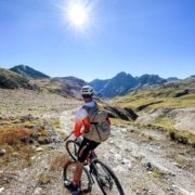 https://pedalnorth.com/wp-content/uploads/2025/09/Alex-on-Stelvio-mtb-route-2025-.jpg
1920
1440
Pedalnorth Website
https://pedalnorth.com/wp-content/uploads/2026/02/Pedalnorth-final-logo-and-wording-for-February-2026.svg
Pedalnorth Website2025-09-08 16:01:012025-09-09 09:23:03Stelvio Pass gravel and mountain bike route – unpaved
https://pedalnorth.com/wp-content/uploads/2025/09/Alex-on-Stelvio-mtb-route-2025-.jpg
1920
1440
Pedalnorth Website
https://pedalnorth.com/wp-content/uploads/2026/02/Pedalnorth-final-logo-and-wording-for-February-2026.svg
Pedalnorth Website2025-09-08 16:01:012025-09-09 09:23:03Stelvio Pass gravel and mountain bike route – unpavedKIT PARTNER
TECHNOLOGY
Tech Partner
Road Bikes
Off Road
Bike Packing
Life Cycle E-Mag
