Nine Standards Rigg
Route Information
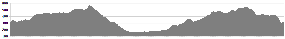
Stats: : 26 miles, 4,600 feet of ascent.
OS Map: ![]()
Refreshments
Depending on season and opening hours, sustenance may be sought at Keld, Kirkby Stephen and the Tan Hill Inn.
Character
There’s a distinctly North Pennine feel to this loop – it’s higher, wilder and wetter than most Dales rides. Expect frothing rivers, Lagavulin-brown with peat and long stretches where the only movement is flitting pipits. The route bestrides the main watershed of northern England so there are a couple of substantial climbs, but these are partly alleviated by tarmac. Expect to use map and compass skills across the moorland sections and try not to have overoptimistic expectations of distinct, dry, free-rolling tracks.
Possible bonus section: For an extra climb, park in Muker and get to Keld over Kisdon Hill, returning via the Upper Swale.
Route
1. Leave Keld on the B6270 signposted to Kirkby Stephen. It’s a long, draggy climb if the wind is in the western quarters but the river scenery of Birkdale more than makes up for it.
2. Just after the watershed (and the Cumbrian border), a bridleway forks off to the right. Follow this on a northerly bearing over limestone scenery, then veer north east across the flank of Nine Standards Rigg.
3. After climbing up from a second major stream, turn left on a northwesterly bearing, picking up a stone wall. The bridleway eventually reaches a roadhead.
4. Follow tarmac down, past quarries, to the charming village of Hartley. If hungry, go down to cross the Eden to sample Kirkby Stephen’s manifold delights. If minimising mileage, follow lanes straight to Winton.
5. Head out of Kirkby on the A685 towards Brough. Fork right to Winton and follow lanes through the hamlets of Rookby and Heggerscales.
6. The road becomes a rough track down to Wrenside Farm. Veer right here, through a couple of fords. Ignore the quad-bike trail going straight up and keep to the wall, past a ruined barn.
7. Ford the rather Old-Testament-sounding River Belah and head upstream over rough terrain. At the charmingly-named Woofer Gill, it gets rougher still. Shoulder the bike, climb out of the ravine on your left and follow a precarious trod that would give a mountain goat pause for thought, never mind a horse and rider.
8. Head out over open moorland towards a new plantation of ash and rowan. At the time of writing (October 2011) these are no more than a foot tall, clad in plastic tubes. You may have to vault a low fence to escape the new wood.
9. Look up the slope for a cruciform bridleway sign pointing downhill from the road. This will be your only guide – don’t expect a distinct trail on the ground. Turn right and follow the road to the Tan Hill Inn.
10. Straight out of the inn’s front door, the Pennine Way heads south. This starts off dry and stone-based but soon reverts to marshy type. This is the Pennine Way, remember. Ignore a couple of opportunities to turn right (down to the road) and, where the track goes left through a gap in the wall, go straight on, down to Keld.
Click below for gpx file

