Stanmer City Limits MTB
Route Information
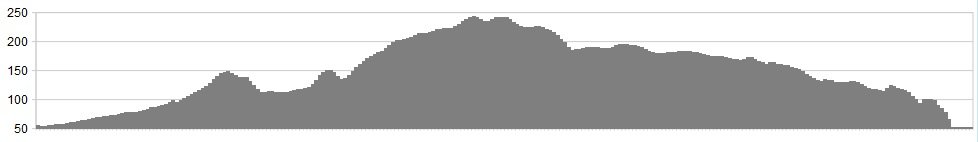
Stats: 8 Miles / 900ft (not including commute from Brighton Central if you fancy the warm up?)
Os Map: ![]()
Refreshments
Free parking can be found at Ditchling Beacon, The Upper Lodges and dotted in and around Stanmer Park. At the beacon you have great views across low weald and east towards Lewes whilst you enjoy a Mr Whippy or you have the delicious home-made food and snacks at the quaint and biker friendly Stanmer Tea Rooms down in the Hamlet.
Character
If you are visiting Brighton to do this ride, why not make a day or weekend of it and enjoy the Bohemian sea-side town by train! By train you can warm up from Brighton station via the road or change trains and head for Falmer which drops you off pretty much outside Stanmer Park. As the title suggests this is all about enjoying the South Downs views and the singletrack of Stanmer all within the city limits of one of Britain’s most vibrant cities.
Route
1. Let’s assume you travel by train for these directions. Entering Stanmer between the two white gate houses that guard the the estate and hamlet of Stanmer, follow the road through the heart of the park, past the manor house, tea rooms (save that for later) until you reach a gate. Tarmac turns to trail as you begin your first ascent out of the bowl that is Stanmer Park. At the fork bear right and climb up to the pylons
2. On at the pylons, there’ll be a bench and cross-roads into the forest. Head straight on as you descend down to Stanmer Down
3. Escaping the trees, the bridleway takes you out of Stanmer on vein of downland singletrack as you climb again towards the South Downs Way (SDW). As you climb the trail you are on is intersected by another bridleway. Turn left and take this new bridleway until you reach the top and join the SDW
4. Turn left/west for a short burst on the SDW before crossing the infamous Ditchling Beacon road and potentially stopping for your Mr Whippy ice cream
5. Demolish the cheeky snack, enjoy the views before heading west again along the SDW for just under ¼ of a mile before taking the bridleway through the fence and gate on your left
6. It undulates for a bit before at first gently accelerating you down a dead straight double track. As the pace quickens you’ll notice the trail looking like it disappears but as you approach fast you want to take the swooping and quick left hander as you are sling-shotted around the banks of the “North Bottom” escarpment
7. Try and keep your speed as the trail flattens and gently climbs towards the exit gate and the Ditchling Road
8. Taking care to cross the road you’ll see the trail dives in the trees and you are back inside the trees line of Stanmer Park
9. Once in hang a right and follow the double track, hard pack trail to the first gate, through the gate you are back in the open on grass as you ride parallel with the road on your right heading towards “Upper Lodge Woods”
10. As you enter “Upper Lodge Woods” you’ll notice trails diving off into the tree’s to your right. Feel free to take these trails as they will wind you down and spit you back onto the main double track trail (feel free to repeat as you will not of lost any height, so riding back up to the gate and repeating is more than doable but there is plenty more to come)
11. Crossing the Upper Lodge access road ensure you stay on the double track and bear right as it forks. In this set of woods there are loads of singletrack and a smorgasbord of fire roads. From here on in you can pretty much explore what you come across. Everything that heads down and is a descent will most likely bring out onto another fire road or the open playing fields of Stanmer near the white gates houses at the entrance to Stanmer
12. My advice is to explore Stanmer and follow your nose. It’s hemmed in by roads and like I said earlier, if the trail heads down then you’ll eventually find your way back to those white gate houses. Once you’ve had enough take the short flat ride up to the tea rooms and enjoy a great home-made lunch with great tea or coffee
Click below for gpx file

