Tour de Rings – South Downs
Route Information
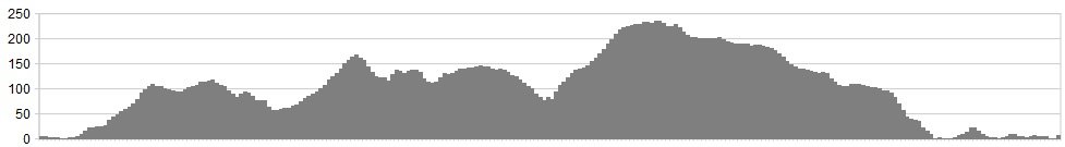
Stats: 17 miles and 1900 feet of ascent
OS Map: ![]()
Refreshments
Dropping off the north face of the South Downs just after you’ve passed Chanctonbury ring on one of the bridleways, will spit you out into the typical Sussex villages of Steyning and Bramber. Here there are plenty of tea rooms and oak beamed pubs to refuel at, but beware of the climb back up to finish this route – or take the Downs link cycle path that hugs the river back to your car. Check this out on the OS map. At the end of the ride, leave the car by river and amble into nearby Shoreham By-Sea to sample the cosmopolitan cafes and riverside bars
Character
A locals favourite on this part of the South Downs. It’s very much a smorgasbord of undulating and varied bridleways in this neck of the woods with a multitude of loops and extensions. This 17 miles takes in the two iron-ages hill forts of Cissbury and Chanctonbury rings with the perfect mix of what the South Downs does best. Rolling undulation, fast white singletrack, sea views and long challenging but rewarding climbs and flat out XC!
Route
1. Leave the car at Cuckoo Corner car park on the Coombes road which is free but does have a height restriction. You could leave the car in nearby Shoreham By-Sea as many of the residential streets are quiet and without restrictions
2. Turn left out of the car park back onto Coombes road and take the first right that is the entrance to the Hogwarts style Lancing College. Continue to ride up the college entrance road past a row of houses and the first Bridleway will be coming up on the left just past the houses
3. Once through the gate continue the gradual climb for the next 1.7 miles taking in the views of the exclusive college on your right as you run parallel with the A27. Losing the views to the enclosed trees eventually you roll out to into open downland with the sea on your left
4. Descend down as you hug the contouring ridge line of Steep Down with its chalky ruts that have plenty of features for pumping and finding your flow
5. At the bottom of the chalky shoot you’ll come to a crossroads of bridleways, turn left to start your roller-coaster of flat out double track before the fast climb towards the Bostal Road. At the top cross the road and go through the adjacent metal gate before you continue down another fast double track bridleway towards Canada Bottom
6. Blink and you’ll miss it, but continue straight through the next bridleway crossroads, into the steepest but shortest descent of the ride as you rattle on towards Canada Bottom. Keep your momentum high as you seamlessly roll onto “Hateful Hill” (namely on Strava) as you approach the car park at the foot of Cissbury ring.
7. Once at the top of the “hateful” drag you’ll go through a metal gate into a small carpark for Cissbury. Take the gate on your immediate left and follow the wide snaking white road of chalk as it cheekily makes you grind up to the top before exposing the sea views and ancient hill fort
8. Stay on the chalky road with the sea directly in front of you, you’ll bear to your right on a sweeping curving fire-road which throws you into a fast flinty descent before another cheeky lung burner as you make your way around Cissbury Ring from East to West
9. Through the gate at the top of that kicking but short climb, take a breather to enjoy the sea view and green flanks of Findon Valley
10. Continue your circumnavigation of Cissbury by following the bridleway signs round its western flank past Shipdens Holt. Hugging the treeline you’ll pass through a gate before open grassland gives you a full view across Findon Valley
11. Continue on but stay high on the obvious grassy trail, through a second gate
12. Up next, is one of the finest pieces of South Downs singletrack as it winds across the contours with tight twists and an almost perfect flow that eventually spits you out back at the North side into the carpark
13. Head due north on the main bridleway/farm track for 0.5 miles before turning left into what feels like you are entering some fields. After 0.1 mile take the right hand fork and begin the long and gradual descent that hugs a hedge line before rattling you down a rooty fast treeline channel and delivers you out at a farm house on your left
14. Continue past the house on the tarmac and spot a bridleway pointing across a cambered horse paddock. Through the gate and across the field. Once out the other side repeat and go through one last field before picking up a gravelled and flint laden road as you turn left after shutting the last gate out of the second field/paddock
15. Once up the steep but short climb turn right at yet another crossroads of bridleways and begin the gradual climb from the valley side to intersect the South Downs Way before reaching the top and Chanctonbury ring with its perch on the North edge of the South Downs ridge
16. Once at Chanctonbury enjoy the views across the low weald as you peer Northwards and on a clear day a view of the Isle Wight can be enjoyed as you complete your 360 degree panorama
17. Continue on the South Downs Ways, straight into a super fast grassy and flinty descent which is a big reward for the climb up to Chanctonbury. Still going after 2 miles of undulating fast cross-country you’ll come out on the apex of the Bostal Road. Take care when coming out and turn right onto the road and continue on
18. Do not miss the South Downs Way sign on your left as you leave the road and begin the drawn out but fast descent across the upper grasslands, past the high pig farm towards the final race towards the river basin. As the gradient steepens past the pigs it’ll bear right and funnel you into a flat out bumpy finish where the brakes will earn their keep before the gate
19. You’ll exit onto the Coombes road, turn right and take the casual 2 mile pedal back to the car at Cuckoo Corner.
Click here for gpx file

