Tour of Bradfield
Route Information
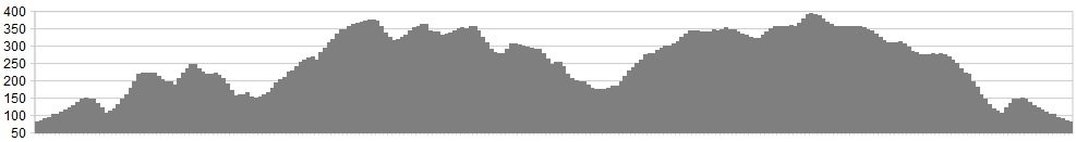
Stats: 26 miles and 2895 feet of ascent
OS Map: ![]()
Refreshments
Due to the short distance and hilly terrain, you may wish to leave any refreshments until after the ride. There are a number of pubs on the route and cafes at the garden centres on the road up Loxley Valley.
Character
Only a fairly short ride, but a tough one at that. You will need to pack your climbing legs for this one and the smallest chain ring may get some additional wear! This rides takes you up the Loxley Valley from Sheffield, and out around the countryside around the villages of Bradfield, an area visited by Stage 2 of Tour de France in 2014. Most of the route is on very quiet roads, but is seldom flat. The ‘Cote de Bradfield’ climb from the tour is included in the route.
If Strava segments are your thing, check out the names and times of the riders at the top of the leader board for this climb. You may recognise a few names and maybe, just maybe, you may decide to take them on!
Route
1 Head out up Loxley Road towards Bradfield.
2 After the road has flattened out, take a right down Rowel Lane just after the garden centre.
3 After you have crossed the bridge at the bottom, take a left turn up Spout Lane.
4 At the top of Spout Lane, make a sharp right turn towards the village of Dungworth.
5 Remain on the same road, passing through Dungworth and then exercise caution on the descent towards the Damflask reservoir.
6 Make a right turn when you reach the reservoir and take the anti-clockwise route around the dam (turning left at the end of the dam wall).
7 As you reach the village of High Bradfield you will need to make a second right turn onto the ‘Cote de Bradfield’.
8 At the summit, make a sharp left turn towards Edgemount.
9 Turn left at the T-junction towards Bradfield/Edgemount and then left again.
10 After a short descent, you then turn right and begin climbing again up Penistone Road.
11 Continue on Penistone Road until you arrive at the junction with Mortimer Road.
12 Turn left onto Mortimer Road crossing another bridge after a sharp descent.
13 After the bridge and subsequent climb, take your first left turn as the road goes to the right (Windy Bank).
14 When you reach the junction, after riding past the reservoir, take a right turn towards Strines/Derwent Valley.
15 After a short distance take your first left turn and after a very brief descent you will be talking the ‘Blindside’ road climb.
16 Turn right at the T-junction onto Sugworth Road, signposted ‘Strines’.
17 Turn left at the next junction signposted Derwent Valley’
18 Turn left when you reach the A57 signposted Sheffield/Rivelin.
19 Take you first left turn as the main road turns right. You will immediately begin to climb, so have your small chain ring ready!
20 Stay on this road for a few miles. You will eventually arrive in the Stannington Village.
21 Take three consecutive left turns carefuly following the signs for Dungworth/Bradfield.
22 You will eventually meet the top of the first STEEP climb you did on the way out (second climb of the day). From here it’s just a case of two left turns (caution with the steep hairpin bends) following the way back you came out.
Click below for gpx file

