Upper Borrowdale
Route Information
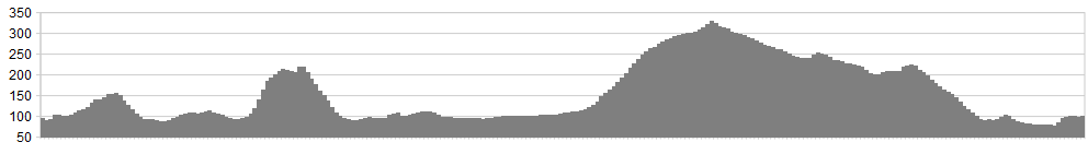
Stats: 10 miles and 1850 feet of ascent
OS Map: ![]()
Refreshments
Honister Yew Tree, Grange cafe or Grange Cottage Tea Rooms
Character
You’ve got to love a valley with jaws. Is there a place name anywhere in England’s pastoral sweep more apt to stir the blood than the Jaws of Borrowdale? As redolent of adventure and exploration as the Gap of Darién, it speaks of heroic struggles through goblin-ambushed gorges to hidden kingdoms beyond.
And, for once, reality doesn’t disappoint. The wide scoop of the lower valley, with Derwentwater lying placidly in its basin, gives every appearance of terminating in the richly-wooded ramparts of Grange Fell and Castle Crag. But the intrepid explorer, machete clutched tight, finds a narrow slot cut by the rushing waters of the Derwent and a second Borrowdale reveals itself.
Best of all, you can get all of that without battling marauding orcs or contracting swamp fever. This is Wainwright’s “loveliest square-mile in Lakeland” and the adventure is open to any machete-less explorer who can find the B5289 on a map.
This ride, though short, takes in the finer legal highs around the upper valley. You can easily thread it onto a longer ride around the lower valley too. That would include the incomparably beautiful terrace of Catbells, also a longish road section along Derwentwater’s eastern shore and a tarmac haul up to Watendlath. Lots of people do that so let’s try something a little bit different, eh?
Start point: There’s a handy pull-in on the left (heading south) just after the drive to Troutdale Cottages.
Route
1. Take the bridleway to Troutdale. This is one of the most beautiful side-valleys in all Lakeland – a demi-paradise of craggy, tree-clad slopes. Keep the stream on your left and bear generally right. This is climbers’ country so make sure you don’t stray onto any of the paths going up to the left. If you’re not careful, you’ll end up carrying the bike across the slab-traverse on Troutdale Pinnacle and then you’ll be sorry.
2. The picture on the left shows the point at which the route-finding becomes tricksiest. With the stream just a few feet to your left and a footpath skirting it, the bridleway veers right, over a small rocky step, after which it becomes better defined. Cross a meadow (picture, right) with a sizeable boulder, admiring the twin cathedrals of Black Crag and Greatend Crag rising up to your left. Now drop down to the road.
3. Turn left on the road, poised to fork left onto bridleway 500m later, at Bowderstone Car Park. This takes you past the sensationally-balanced sugar cube and drops back down to the road.
4. Again, look out for a left, to Frith Wood, where the road leaves the trees. Climb, with enthusiasm, to an open fell with a beautiful ribbon of singletrack traversing round to the Hazel Bank descent.
5. Descend, with even more enthusiasm, to Rosthwaite. Avoid the road by taking the charming bridleway to Stonethwaite along the intake wall. Double back over Stonethwaite Bridge and rejoin the B-road at the notice-board an post-box.
6. Turn left and trundle up the road through Seatoller. Either turn right immediately after the village onto the permissive bridleway or keep going up the pass. Either way, you’ll gain a great trail skirting the flank of High Scawdel. This will lead to the peregrine-stooped rocks of Castle Crag and the great descent of Broadslack Gill to the beautiful banks of the loveliest square mile. Then you can coast down to Grange (choice of two great cafes) and the double-bridge back to the start.
Click below for gpx file

