The Colle dell’Agnello is a mountain pass in the Cottian Alps, west of Monte Viso between France and Italy which links the Queyras valley (Hautes-Alpes) with Pontechianale in the province of Cuneo, Piedmont.
At 2,744 m (9,003 ft), it is the third highest paved road pass of the Alps, after Stelvio Pass and Col de l’Iseran.

Route Information
Stats 123 km 3736 metres
Refreshments & Where to Stay
We start this ride in the mountain town of Sampeyre, with a stop at Abries after summitting, where you can either stay over and ride back the next day, or eat and refresh yourself before the return journey.
Character
This is a tough and long day in the saddle if you do it as ride to Abries and a return ride. There are options though. You can simply descend from the summit or ride to Abries, and then decide if you want to ride back or take a stay in the small but picturesque mountain village.
Route
- Start at Sampeyre in the Italian mountains and follow the SP105 road towards France!
- Switchbacks begin after 8km and the climbing gets serious. At 10km turn through the village of Casteldelfino, taking in the narrow cobbled streets and architecture, before rejoining the SP105 and continuing upwards.
- At 14.5km the Lago di Castello is seen on the left and the road strangely becomes the SP251 without you noticing,as this narrow but good road skirts the lake.
- Passing by the village at the end of the lake, there are options for refreshments on the return. Once passed the village, the area becomes more remote and the road steepens and twists its way through the mountains.
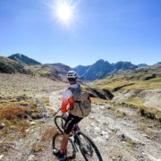
- Serious switchbacks are met at 25km as you close in on the summit, and then the isolated mountain col is reached, with nothing more than a large parking area and depending on the weather, amazing mountain views ito France and Italy.
- Descending will be tough and cooler, so wrap up and prepare for the descent and do so safely and within your riding limits.
- Descend to the 50km point, on the D205T (France), then joining the D5, and at La Casse , cross the bridge and at the roundabout turn right onto the D947 .There are options here for refreshments if you want to cut short the full ride and ride back after a rest to eat and drink.
- Failing that, ride on the D947 to Abries, passing by the village of Aiguilles along the way. Now, the only choice is to stay the night and rest, or do the epic return journey after refreshments.
Click below for GPX file
Download GPX