A climb for all seasons
Church Bank, Nidderdale
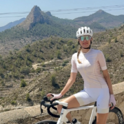
As a cycling venue Yorkshire is hard to beat; whilst it may not have the endlessly long climbs of the Alps and elsewhere, it does have a plethora of savagely steep climbs that hit you in quick succession. Jere in the Yorkshire Dales National Park, you’d have difficulty finding a hill that has a gradient sign unless it’s over 12% – they’d simply run out of signs! We thought that as Yorkshire is the heartland of where Pedalnorth began, we ought to produce a guide to our favourite killer climbs.
Church bank is an unrelenting wall of tarmac, on a narrow and winding climb that never seems to ease off… until the summit. Whilst not the steepest, it is very likely to hill that requires the most spirit and determination.

Many of them you’ll recognise, but there’ll be a few that are new to you, unless you’re a local and know the secret roads that wind their way around this beautiful corner of the U.K.. We thought that we’d start things off with a surprise choice, taking you up Church Bank at Pateley Bridge in Nidderdale, with a short burst up the Devils Elbow climb too. For most cyclists, Pateley Bridge brings forth images of Greenhow Hill, used on the Tour De France, Tour de Yorkshire and the recent World Road Cycling Championships. However, Church Bank is steeper, tighter, more twisty and more painful, whilst still leading you up to amazing views across the wild and beautiful landscape of the Dales. Let’s get climbing then …

Total distance: 43 km
Total ascent: 710 metres
Start: Park in the main car park at Pateley Bridge, or ride into the valley from your local home.
Refreshments: Lots at patley Bridge, and a cafe at Fountains Abbey (halfway)

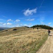
Ascending Church Bank
The route starts from the car park adjacent to the river in Pateley Bridge, and without any warning it immediately throws you onto a climb as you turn right and head up the famous High Street a a gradient of 9%. Passing Kendals Butchers on the right and the oldest sweet shop in England on the left, the road ahead bends sharply right, but not for us – we simply start to pray and cycle straight ahead, turning onto Church Lane.
The climbing is steep from the start as you weave past the houses on either side before the road narrows and hits 20%+ as houses and cottages are soon left behind. Trees and hedgerows lime the dark lane ahead, adding to the foreboding nature as the road begins to bite. There’s no room to weave, and you simply have to grit your teeth and crank it out. Short respites are given as you cycle up mere 14-20% sections, before cottages on the right hand side break out from the trees and the road bends to the left and stays steep and unrelenting.
Church Bank Summit to Devils Elbow
The tree line is finally cleared and the road edges up in a traverse that hangs on the side of the Nidderdale valley. A bench to the left of the road gives an opportunity to rest and to take in the magnificent view, but we prefer to suffer and climb. Passing the bench, the road soon winds back to to right and the gradient once more steepens towards 20%, passing a farm lane to the left and footpath sign to the right. Your eyes open to the easier road ahead as things start to relent, having given you a 1.5 km sufferfest. Passing the road junction signed to Blazefield on the right, the climbing is now straightforward but continuous, with open views all around.
Eventually, as you see large glacial boulders in the field to the right at around 2.5 km, it’s safe to say that Church Bank has been conquered. The road now winds it’s way through spectacular moorland, with birds of prey flying overhead, as you head towards the next challenge – the short but steep Devils Elbow. At around 5.5 km a junction is reached and you turn left, dropping down to the sharp bend (the Devils Elbow) and the road rises to 20%. The grind is however short lived, as once you bend to the left it eases off and takes you once more through open moorland scenery.
Devils Elbow to Fountains Abbey
Stay on this road, crossing a cattle grid with care at around 9 km, where the dry stone walled road narrows tightly and sheep meadows create an endless green carpet. At 11.5 km pass the junction to Laverton on your left, staying on the lane as it once again twists and turns and climbs, with picture postcard views all around you. A friend and cycling writer colleague who stayed last year, likened the views to being constantly within a film set, as the countryside was so typical of that seen in the movies.
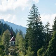
A sharp bend at 13 km signifies the end of the winding roads for a while, as things straighten out. Ahead lies a junction with a wider road – Gate Bridge. Turn left and ride on for another 2 km, reaching a junction on your right signed for Galphay. Take this road on the right and head through Galphay, where the road bends sharply and requires care. At 1 km past Galphay the road drops sharply to a bridge and then climbs at around 14% before easing off and descending on a tight and twisting lane lined by high hedges all the way to Ripon. It’s time now for tea and cake at Fountains Abbey before riding back to Pateley Bridge along the main road.
Via Brimham Rocks back to Pateley Bridge
From Ripon, take the B6265 road that twists and turns and then climbs from the entrance to Grantley Hall hotel, initially up another short 20% hill, before bending to the left and easing off. Follow this road as it then continues to climb, albeit gradually, through Risplith village, which when passed through, increases the gradient once more. The road eventually eases off and heads straight towards Pateley Bridge.
A useful detour 2.5 km from Risplith is the junction and road to the left, signed to Brimham Rocks. Follow this for 3.8 km, them turning down right towards Summerbridge. For the first time today, you get to ride down a steep hill, descending for 3 km to Wilsill and taking the road right for a final 3.5km back to Pateley Bridge and refreshments.
Download the GPX File

Open OS Map

 Tobias Arweiler