Col du Dallowgill
Route Information
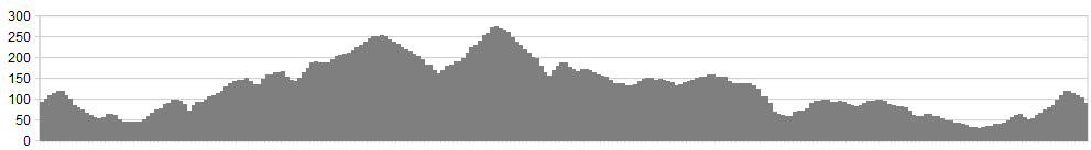
Stats: 32 miles and 2300 feet of ascent
OS Map: ![]()
Refreshments
Fountains Abbey visitor centre is ideal, and has a great restaurant for post ride meals and snacks.
Character
This route takes in the winding lanes on the dge of the Dales to hidden places with superb climbing.
Route
- Head out of Fountains, down through the Deer Park and to the main Pateley Bridge Road. Turn right towards Ripon and then turn left after 300 metres, towards Galthay.
- Go past the Inn and down to the T junction. Turn left and ride the rolling climbs to High Grantley.Just before the village,take the road to the right towards Skelding. Follow this winding lane to the T junction on the moors road.
- Turn right on this road towards Laverton and Dallowgill. Ride over the cattle grid and after the tight and narrow twisting lane take the minor road on the left signed to Dallowgill.
- Twist and climb this awesome country lane, as it guides you to the Col at Dallowgill, with spectacular views.
- Follow the long and rolling road, with testing climbs to the edge of Kirkby Malzeard. Ride the short Laverton Loop before crossing the junction in Kirkby Malzeard and riding to Grewelthorpe.
- At Grewelthorpe take the road towards Ripon for 1 mile before turning left and descending Mickley Bank.
- After the village of Mickley, climb up and turn right onto the narrow lane. At its end turn left and shortly afterwards turn right onto a lane that brings you to the Ripon Road.
- Turn left and ride into Ripon and back to Fountains Abbey.
click below for gpx file

