Cold Fell
Route Information
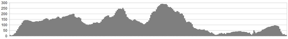
Stats: 38 miles and 3400 feet of ascent
OS Map: ![]()
Refreshments
Whitehaven has sufficient places to eat and rest.
Character
A grand circuit of Cumbria’s western seaboard. Hope for views of the Isle of Man from Cold Fell as well as mysterious signs of our ancient ancestors. This is a reference to archaeology, not the fact that your geriatric Routes Editor has passed this way.
Route
Starting in Whitehaven on the Cumbrian coast, this route weaves inland to take on one of the most iconic of local climbs.
Following good roads that skirt the edges of remote Ennerdale, climbing to the heights of the lower Lakeland Fells, you then descend at speed – and with care – back towards the coast, for an easy ride home. This route is simply a case of following the gpx and Google map, with few difficulties for navigation.
- Head out of Whitehaven on the minor road towards Distington.
- After 2 miles, a junction on the right is signed towards Pica take this and follow the road.
- Ride all the way into Ullock, then following the road through the village until the junction with the A5086. At this junction, turn right and ride on the minor road towards Crossgates, but turning off shortly after joining this road, onto the junction on the left signed towards Lamplugh and Ennerdale continuing on this road until the junction is seen on the left, signposted to Ennerdale.
- This beautiful, narrow and hedgerow lined country lane now weaves its way though the valley, rising and falling.
- Climbing steeply onto the fells, the stone circle at Blakely Raise is passed on your left, before the road evens out then starts to descend.
- After taking in the history, descend with care to Calder Bridge, before turning off to Netherton and the coast road back to Whitehaven.
Click below for gpx file

