North Pennine Loop
Route Information
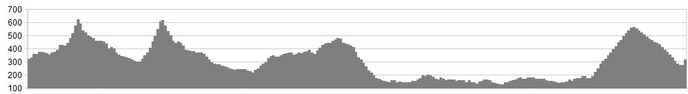
Stats: 75 miles and 6340 feet of ascent
OS Map: ![]()
Refreshments
Cafes at Nenthead, Killhope Mines, Saint John’s Chapel, Middleton-in-Teesdale, Brough, Appleby, Melmerby, Hartside Pass, and Alston.
Character
A loop of the south western portion of the North Pennine AONB, taking in the highest passes and the flats of the Eden Valley.
Route
1. Join the Stanhope road and pass through the village of Nenthall then on to Nenthead.
2. Carry on through the village onto the climb of Killhope Cross, pass the Allenheads turn and begin the triple ramped climb to the stone cross at the summit, which is the highest A road in England.
3. An incredible descent takes you into Weardale past the Killhope mines museum and on through Lanehead to Cowshill, take the right fork then through the pretty villages of Wearhead, Ireshopeburn and Saint John’s Chapel.
4. Take a right turn just before the village hall signed for Langdon Beck and begin the climb of Chapel Fell. The road takes a sudden dip then rises again, straightens to cross a cattle grid then small stone bridge and just gets steeper and steeper as it bends back and forth until finally reaching the summit at the quarry, this is the highest paved pass in England.
5. Drop down the other side and turn left at the end and follow the road all the way through Teesdale past High Force and into Middleton-in-Teesdale.
6. After the bridge turn right then a left for Brough. Passing the reservoirs the road steps up in stages onto the moors then drops down into Brough.
7. Go through the high street then take a left signed for Great Musgrave then the left signed Kirkby Stephen then the next right and pass through Little Musgrave.
8. Carry on to the cross road with Mask Road and turn right for Appleby.
9. Enter the town, and cross the bridge, turn left the follow the road out of the town, under the A66 and on to Long Marton, Milburn and Blencarn. Keep going through Skirwith, then to Ousby where a right turn leads to Melmerby.
10. Turn right in the village and begin the 5 mile long but steady 5% or so climb up out of the Eden Valley to Hartside Pass.
11. A long descent to Alston then turn right onto the steep cobbled high street.
Click below for gpx file

