Osmotherley Introduction
Route Information
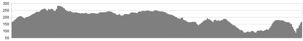
Stats: 15.4 miles and 1858 feet of ascent
OS Map Link: ![]()
Refreshments
Osmotherley is one of the most picturesque and yet easily accessible villages within the Moors National Park. Two good pubs, a great chip shop, and a fantastic tea room to boot. It also has some of the cleanest public toilets in the country – officially! Ample accommodation in the area, including a great campsite nearby.
Character
This is a fantastic introduction to Moors riding. Don’t look at the middle section as 5 miles of toil – it’s 2 1/2 miles of toil, followed by a great downhill section. From Square Corner – yep, check the map name – I’ve taken this route down the Cleveland Way and past the reservoir. However, this is a footpath, so we can’t condone riding this. Either GOAW or take it steady and walk if there are hikers around. It is however too good a descent to avoid totally, if the opportunity exists.
Woodland, hard climbing, fast dusty descents and technical moorland singletrack, this is a great introduction to the area.
Route
1. Start at Osmotherley village and head up North End towards the Moors and Cote Ghyll.
2. Passing the national speed limit signs, a track to the left shows signs for ‘Swainstye Farm’ – take this and follow the bridleway as it climbs up towards Skarth Wood. Gates lead through to a terrific track that descends through a heather clad scene, towards ‘Skarth Nick’ . This really is a superb descent.
3. Crossing the road, turn left over the cattle grid and almost immediately take the BW (Cleveland Way) into the woods on the right and pedal on fine woodland trails, continuing on the Cleveland Way signs as it descends to your left (track junction.)
4. Descend and cross over the woodland track, keeping to the Cleveland Way and climb to Harfa Bank Farm, passing Harfa Bank Farm and continuing along the track in the image to the right. Another red coloured metal gate leads onto a metalled road – turn right) and head along the Scugdale valley, with Barker’s Crag above you to the right. This gate may be locked and require a clamber over.
5. At Scugdale Hall go through the gate, and take the track for cyclists signed to the left. This climbs on tricky ground up onto the Moors proper. A gate finally leads through onto Moorland. Rest here before a short track joins the main Moorland track, turning right and following the bridleway along Barker’s Ridge.
6. Keep to this bridleway, descending Arnsgill Ridge to Rye farm and tarmac. At Low Cote Farm go ahead and down the hill towards Hawnby for about 1/4 mile, before taking the bridleway through the gat to the right. This bridleway climbs on grassy tracks, before traversing a rocky moorland singletrack that will require good line choice and balance.
7. Rejoin the road and turn left towards ‘Square Corner’ and the chance to rest and take in the myriad of tracks that abound this area.
8. At Square Corner follow the road back towards Osmotherley until a BW leads off straight ahead at a corner and bend to the left. This rough track can be technical and descends rocky ground to the Sheepwash.
9. On descending the steep and rocky track down to the Sheepwash take care. It is extremely technical. Ride through the ford and turn left onto the tarmac road and head back to Osmotherley.
Click below for gpx file

