Richmond to Tan Hill
Route Information
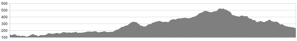
Stats: 49 miles and 2466 feet of ascent
OS Map: ![]()
Refreshments
As recommended, the Coop car park may be best, or find suitable off street parking. If you book a B & B for your return, they may let you park in advance. Ample accommodation options in the town. On route, stay overnight if you want to, at the Tan Hill Inn – but book in advance. They do allow camping at the Inn. If done in one day, this fast becomes a hard ride.
Character
Reeth is an excellent stop off point along this ride, in both directions. This ride takes in the beauty of the Northern Dales. Stunning valleys give way to peaks and ridgelines, old lead mine workings and spoil heaps, showing the old industrial nature of the northern dales.
Quiet roads climb up over 1600ft to the famous Tan Hill pub and hotel. It can be bleak and breezy at times, so take suitable clothing along with you. This is the highest pub in England and by the time you get there you will be ready for some refreshments. The return leg of this route drops down south through quiet lanes, passing through Gunnerside, once an industrial hot spot for lead mining. The B6270 gently descends east back to Reeth and back to your start point.
If you are considering staying in Richmond there is plenty of accommodation. One night either side of the ride could make a three night holiday in the Northern Yorkshire Dales
Route
Day 1: 22.5 miles
1. Park up in any part of Richmond. There is plenty of pay car parks but you will need to check on parking limits if you are staying overnight.
I’ve started the route in the Coop Car Park and again check on parking limits. It wouldn’t be nice to come back to a ticket.
2. Follow the Reeth road west out of Richmond. Good quality road and at this stage you are following the River Swale west so the going is pretty good. It’s a 10 mile ride to Reeth, which has plenty of refreshment houses and is a great place for a break before some serious climbs.
3. Follow the Arkengarthdale Road to the village of Langthwaite and beyond. You will be climbing hard now. Follow this lane all the to the Tan Hill Inn. (Overnight Stay optional)
Day 2: 28 miles (if staying over at Tan Hill)
1. Turn right out of the Tan Hill having had a restful night’s sleep and a pint or two. Follow the lane and take the next left.
2. This lane is heading south and pretty much straight and fast with a slight downhill angle to it.
3. Having dropped down Stonesdale Lane you will meet the B6270 at the River Swale with Wain Wath Force waterfalls nearby and well worth a look. Turn left.
4. Follow the B6270 back to Reeth passing through Muker and Gunnerside. This route will take you through the beautiful Swaledale valley and back to Reeth.
5. From Reeth follow the B6270 for 10 miles back to Richmond.
Click below for gpx file

